Chapter Two: Understanding Flood Risk
Learning Goals
By the end of this chapter, you will be able to:
- Understand how flood risk is determined.
- Identify the role of different agencies in establishing flood guidelines and building codes.
- Describe the methods used to assess flood zones and the impacts they have on infrastructure.
Introduction
Flood risk is the assessment of the potential for flooding in a specific area and the potential impacts on people, property, and infrastructure. It involves the analysis of various factors such as historical flood data, geographical characteristics, climate conditions, and land use. Understanding flood risk is vital for effective flood management, mitigation, and long-term planning. Properly assessing flood risk enables communities to implement building codes and infrastructure standards that reduce damage and enhance resilience.
This chapter will focus on how flood risk is determined, the role of agencies involved in the process, and how these assessments are used to create effective flood mitigation plans.
Determining Flood Risk
Flood risk is determined through the assessment of multiple factors that contribute to the likelihood and severity of flooding. These factors include:
Historical Flood Data
Examining past flood events is crucial for understanding patterns and predicting the likelihood of future floods. Historical data provides insight into the severity, frequency, and areas impacted by previous flooding. This helps to identify trends and potential vulnerabilities, guiding the preparation for future events.
Geographical Location
Areas that are geographically located near bodies of water such as rivers, lakes, streams, and oceans are naturally more susceptible to flooding. The topography of an area (e.g., its elevation and slope) also plays a significant role in flood risk. Low-lying areas are more prone to flooding, while higher elevations are less vulnerable.
Soil and Vegetation
Soil type and land cover significantly influence the way water behaves during a flood. Areas with dense vegetation and absorbent soil types are better at absorbing and slowing down floodwaters, reducing the risk of flooding. In contrast, areas with compacted soil or minimal vegetation, such as urban environments with paved surfaces, are more likely to experience surface runoff and rapid flooding.
Climate and Weather Patterns
Weather conditions such as heavy rainfall, frequent storms, snowmelt, and rising sea levels due to climate change are key factors in determining flood risk. Changes in precipitation patterns and increased extreme weather events (e.g., hurricanes and heavy rainfall) contribute to heightened flood risks in many areas. As the climate continues to change, flood risk may increase in areas previously thought to be at lower risk.
Role of Agencies in Flood Risk Management
Several agencies and organizations are integral to determining and managing flood risk. These agencies conduct research, produce flood maps, set building codes, and provide financial assistance to communities impacted by flooding.
Federal Emergency Management Agency (FEMA)
FEMA plays a central role in the U.S. flood risk management system. It produces Flood Insurance Rate Maps (FIRMs) that identify flood-prone areas and define flood zones. FEMA also manages the National Flood Insurance Program (NFIP), which provides flood insurance to homeowners and businesses in flood-prone areas. These maps and policies help communities understand flood risks and develop strategies to reduce damage.
American Society of Civil Engineers (ASCE)
ASCE sets standards for building in flood-prone areas. ASCE-24 (Flood Resistant Design and Construction, ASCE/SEI 24-24) provides guidelines for designing and constructing buildings to withstand flooding. The standard addresses various aspects such as building elevation, floodproofing, and specific requirements for coastal hazard areas. By incorporating ASCE-24 into building codes, communities can ensure that new structures are built to minimize flood risk.
Flood Mapping
Flood maps are essential tools used by communities and agencies to assess flood risk and make informed decisions about floodplain management. They identify areas vulnerable to flooding and categorize them into different flood zones based on risk levels. FEMA’s Flood Insurance Rate Maps (FIRMs) are the most widely used maps for this purpose.
Flood Zones
Flood zones are categorized based on the likelihood and severity of flooding. Areas with a 1% or greater chance of flooding each year are designated as Special Flood Hazard Areas (SFHAs). These zones include areas with the highest flood risk, such as Zone A (highest risk), followed by Zones B, C, D, V, and X (lowest risk).
- Zone A: High-risk areas with a 1% or greater chance of flooding annually.
- Zone V: Coastal areas at risk of storm surge and wave action.
- Zone X: Areas with a low or minimal risk of flooding.
Understanding flood zone classifications is crucial for homeowners, developers, and local authorities. For example, residents in high-risk areas (Zone A) may be required to purchase flood insurance, while communities may implement restrictions on development to mitigate potential flood damage.
Flood maps are created using a combination of historical flood data, hydrological models, geographic analysis, and topographic surveys. These maps help predict flood scenarios based on rainfall, river flow, and other hydrological factors. As climate change increases flood risks, accurate flood mapping is becoming more critical for community safety.
Building Codes and Flood Risk Reduction
Building codes play a vital role in reducing the impact of floods by setting minimum construction standards for flood-prone areas. The goal is to ensure that buildings and infrastructure are designed to withstand flood events and minimize damage.
- Base Flood Elevation (BFE): One of the primary measures in flood zone building codes is the Base Flood Elevation (BFE). This refers to the elevation at which floodwater is expected to rise during a 100-year flood (a flood with a 1% chance of occurring each year). Buildings in flood-prone areas must have their lowest floor at or above the BFE to reduce the risk of flooding.
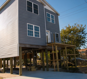
- Elevated Foundations: In flood-prone areas, one of the most effective strategies to mitigate flood risk is elevating buildings above expected flood levels. Elevated foundations raise structures, such as homes and businesses, above the level of potential floodwaters, reducing the risk of damage.
- Floodproofing: Non-residential buildings may use floodproofing techniques such as sealing or waterproofing structures to prevent water from entering during a flood event. These measures help protect property and reduce long-term repair costs.
Conclusion
Understanding how flood risk is determined is critical for effective planning, response, and mitigation strategies. Key factors such as historical flood data, geography, soil types, and climate patterns all contribute to assessing flood risk. Agencies like FEMA and ASCE play a crucial role in establishing flood guidelines, building codes, and flood mapping systems to enhance community resilience and minimize flood damage.
Flood mapping and building codes are essential tools in reducing flood risk. By prioritizing accurate flood assessments and implementing strong construction standards, communities can ensure the safety of their residents and infrastructure while preparing for future flood events.
Definitions
- Flood Risk: The likelihood of flooding occurring in a specific area, considering factors like historical data, geography, and climate conditions.
- Flood Insurance Rate Map (FIRM): A map created by FEMA to identify flood zones and risk levels, used to inform flood management and insurance decisions.
- Special Flood Hazard Area (SFHA): Areas with a high risk of flooding, defined by FEMA as having a 1% or greater chance of flooding annually.
- Base Flood Elevation (BFE): The elevation to which floodwater is expected to rise during a 100-year flood.
- ASCE-24: A flood-resistant design standard published by the American Society of Civil Engineers that outlines requirements for building in flood-prone areas.
Review Questions
- What are the key factors that determine flood risk in a given area?
- How does FEMA contribute to managing flood risk through mapping and insurance programs?
- Explain the importance of the Base Flood Elevation (BFE) in flood zone construction standards.
- How do building codes reduce flood damage in vulnerable areas?
Bibliography and Links
- FEMA Flood Maps and Zones: FEMA Flood Maps Explained
- FEMA Floodplain Management and Federal Flood Risk Management: FEMA Floodplain Management
- Flood Risk and Resilience in Louisiana: Louisiana Coastal Master Plan
- ASCE-24 Flood Resilient Design and Construction: ASCE-24 Standard
- Louisiana’s Flood Maps: http://maps.lsuagcenter.com/floodmaps/