Chapter 9: African History to 1500
Charlotte Miller
9.1 CHRONOLOGY
| Chronology | Africa to 1500 |
|---|---|
| 200,000–100,000 BP (Before Present) | Homo sapiens emerged in Africa |
| c. 7000 BCE | Beginnings of the Agricultural Revolution in Africa |
| c. 3000 BCE–1500 CE | The Bantu expansions |
| 900s BCE | Rule of Queen Makeda (Ethiopia) |
| c. 800 BCE–300 CE | Kingdom of Da’amat (Ethiopia) |
| c. 250 BCE | Founding of Djenne-Jeno, one of Africa’s first cities (Western Sudan) |
| c. 100–950 CE | The Empire of Aksum |
| c. 300 CE | Ghana emerged as a state (Western Sudan) |
| c. 325–350 CE | The rule of King Ezana (Aksum/Ethiopia) |
| c. 800 CE | Ghana became an empire (Western Sudan) |
| 1000–1500 CE | Height of Swahili society (East Africa) |
| 1200–1450 CE | Height of Great Zimbabwe (southern Africa/Zimbabwe Plateau) |
| 1235 CE | Sundiata Keita founded the Mali Empire (Western Sudan) |
| 1324–1325 CE | Mansa Musa performed the hajj (Western Sudan) |
| Early 1400s CE | Portuguese began to explore the Atlantic coast of West Africa; beginnings of the Age of Exploration |
| 1460s CE | Sunni Ali built the Songhai Empire (Western Sudan) |
| 1493–1528 CE | Askia the Great rules during the Golden Age of the Songhai Empire (Western Sudan) |
| Early 1500s CE | The Portuguese built a Trading Post Empire in the Indian Ocean (East Africa) |
| 1591 CE | Moroccans invaded the Songhai Empire (Western Sudan) |
| 1699 CE | The Omanis (allied with some Swahili rules) seized Swahili city-states from the Portuguese (East Africa) |
9.2 INTRODUCTION
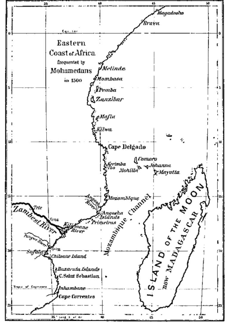
Adventurously sailing the Indian Ocean in the early 1500s CE, Duarte Barbosa, a Portuguese naval officer, was confident that he was helping to forge a new, enduring era of Portuguese dominance. As he passed through several Swahili (syncretism of Bantu and Arabic) city-states on the East African coast, Barbosa noted the brisk trade and the riches of these African settlements where he saw a “great plenty of gold” that would serve Portuguese interests[1]. In his mind, God had destined these stashes of gold for the Portuguese, and the local Swahili rulers acted unwisely and arrogantly to defend themselves. In the conflict that followed, the Portuguese plundered the Swahili city-states, burning buildings and enslaving African men and women. Barbosa boasted that when the Portuguese looted the settlements, they slaughtered many people and took a “great spoil of gold and silver and goods.”[2] Barbosa’s description highlights the violence of Portuguese conquest and also his expectation that he and his countrymen were creating a new Portuguese empire that would make a lasting mark in East Africa and the wider Indian Ocean World. However, less than 100 years later, Portuguese influences were noticeably absent in most of East Africa, and their power in the Indian Ocean was fading rapidly. Barbosa himself had traveled with his brother-in-law, Ferdinand Magellan, and met an untimely end in the Philippines, killed at a banquet days after Magellan himself was poisoned in a battle against local opponents. Writing about the coast of East Africa, Barbosa paid little heed to the hundreds of years of Swahili history that preceded his visit. Therefore, his narrative gives us minimal information about Swahili civilization. This chapter will fill in some of the silences in the written historical record as it describes Africa’s major contributions to world history.
Americans have many common misconceptions about Africa reinforced by contemporary news stories that focus on drought, famine, and war. In addition to associating Africa with extreme hardships, a plethora of western-made TV shows focus on wildlife and the rainforests. However, these popular images do not give an accurate portrayal of the everyday experiences of most Africans or tell us much about the history of the continent.
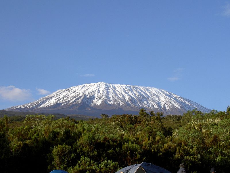
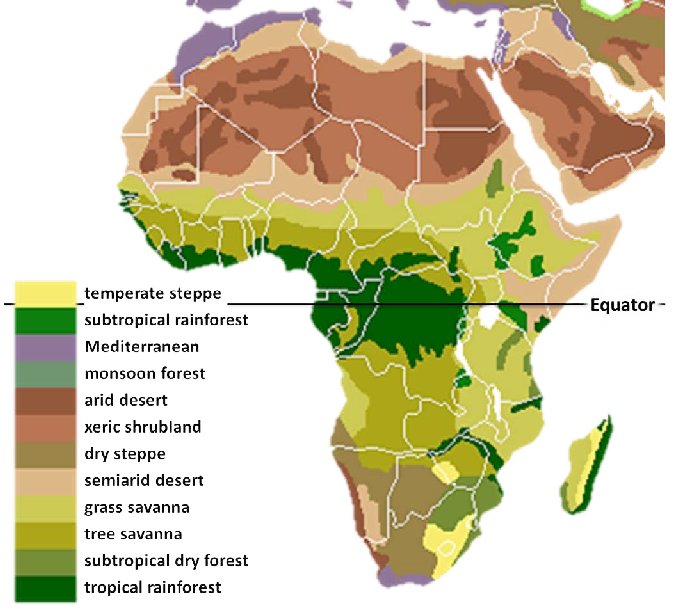
One of the main points glossed over by these popular images is that the African continent is large and diverse. Africa is the second largest continent in the world. Today, it has over 50 independent countries. You can also find just about every imaginable environment—from savannahs, rainforests, and deserts to glaciers and snow-capped mountains—in Africa. Its over 1,000 languages (or about one-third of the world’s languages) also demonstrate the continent’s diversity.[3] Africa is home to more than a billion people, who are living, working, and raising their families.
Historically, Africans faced significant environmental challenges that limited population growth. There are exceptions, but overall, African soils are poor, and rainfall has been unpredictable. The more temperate climates in a number of regions slow the decomposition of organic materials in the soil, meaning that the soil in many regions has few minerals and nutrients. The areas that are exceptions, such as the highlands of Ethiopia, Rwanda, and Burundi, have seen much higher population concentrations. Rainfall also tends to be concentrated in just two or three months a year, while disease has been yet another challenge.
Considering the past 5,000 years of African history, malaria, yellow fever, and trypanosomiasis (also known as sleeping sickness) have made the biggest impacts on population growth and settlement patterns. Even today, all three diseases affect the continent. Both malaria and yellow fever are spread to people by mosquitos. According to the World Health Organization (WHO), despite preventative measures and great efforts to extend the availability of treatments, malaria was responsible for almost 600,000 deaths in 2013. Children in Africa account for most of the fatalities, and the WHO estimates that currently one African child dies from malaria every minute of every day. It causes symptoms like headaches, fever, and chills. Even though it does not usually constitute a medical emergency for adults, malaria does decrease productivity and has significant treatment costs. On the other hand, yellow fever has a high mortality rate—about 50%—even amongst healthy adult populations.[4] While malaria and yellow fever have historically taken the largest toll on human populations, one of the main effects of trypanosomiasis (or sleeping sickness) has been to limit the practicality of keeping certain types of livestock in Africa. Horses and many breeds of cattle, in addition to humans, are especially susceptible to trypanosomiasis. The disease is spread by the tsetse fly and can lead either to chronic illness—characterized by weight loss, fever, anemia, cardiac lesions, and other symptoms—or to a more immediate death. Until the past fifty years or so, in many parts of the continent, these noteworthy challenges with disease, alongside the low fertility of the soils and the unpredictable rainfalls, were significant constraints on human population growth. Environmental challenges and disease also affected settlement patterns as, for example, people avoided more forested and wetter areas because of the prevalence of mosquitoes. Additionally, Africans continuously adapted their herding and farming techniques to overcome these challenges.
9.3 QUESTIONS TO GUIDE YOUR READING
- Describe the environments of Africa.
- Which environmental challenges and diseases have historically limited population growth in Africa?
- Discuss the methodological challenges of studying ancient and Medieval African History.
- Identify commonly used terms that are potentially problematic for scholars of Africa. Explain why these terms are potentially problematic.
- What was distinctive about the agriculture of the Ethiopian Highlands?
- Explain the legend of Queen Makeda and King Solomon and why it remains significant for Ethiopians.
- How were the states in this region shaped by trade and inter-cultural relationships?
- Describe the spread of Christianity into Aksum. What was the role of King Ezana?
- What characteristics were shared by the Western Sudanic states?
- How did the location of the Western Sudanic states have an impact on their history?
- Describe the relationship between the Western Sudanic states and the Islamic World.
- How did nineteenth-century European scholars depict the Bantu Migration? What factors influenced their view?
- How have post-colonial scholars challenged nineteenth-century depictions of the Bantu Migration?
- How did the ruling classes of Great Zimbabwe generate wealth and demonstrate their elite status?
- How are oral traditions, such as the one recounted here about Kilwa Kisiwani, important to Swahili identity?
- Describe the urban style of Swahili city-states.
- Compare the trans-Atlantic and Indian Ocean slave trades.
- How did the Portuguese impact the East African coast?
9.4 KEY TERMS
- African diaspora
- Aksum
- Askia Muhammad I
- Bantu expansions
- Bantu Migration
- Ghana
- Great Zimbabwe
- Griots
- Indian Ocean World
- Kebra Nagast
- Kilwa Kisiwani
- Kingdom of Da’amat
- King Ezana
- Malaria
- Mali Empire
- Mansa
- Mansa Musa
- Monsoon winds
- Queen Mekeda
- Sahel
- Songhai Empire
- Stelae
- Sundiata Keita
- Swahili city-states
- Syncretism
- Timbuktu
- Trading Post Empire
- Tribe
- Trypanosomiasis
- Western Sudan
- Yellow fever
- Zanj Rebellion
9.5 WRITING THE HISTORY OF ANCIENT AND MEDIEVAL AFRICA
Scholars of Africa, particularly those working in the last two generations, have employed all sorts of methods to describe the ancient African past. They have necessarily been on the forefront of methodological innovation because of the limited availability of written primary sources, meaning sources recorded by ancient Africans themselves. Therefore, scholars have turned to a wide range of materials to complement the available written records.
Before about 1800 CE, many African societies kept their records orally, as opposed to in written form. These societies have rich, complex histories that some past historians, relying primarily on written records, ignored when they studied the African continent.
European and American views of Africans during the nineteenth century were generally derogatory and prejudiced. Alongside these views, professional scholars tended to portray Africans as primitive, meaning unchanged from time immemorial. Western methodologies, with their reliance on written sources, backed up European views of Africans as unchanged. Two general results of the nineteenth-century scholarship in the West were the assumptions that Africa, which was commonly referred to as “the dark continent,” lacked a history prior to European arrival on the continent and that any urban developments or complex state structures in Africa were the achievements of outsiders. For example, as you will see in this chapter, there were nineteenth-century European scholars who credited people from Yemen with building the Axum trading empire and attributed the archaeological findings at Great Zimbabwe to Phoenicians. Especially since the 1960s, there has been a strong movement to reclaim these (and other) developments as African. As part of this effort, scholars employ new methodologies, including the study of oral sources, archaeology, climate change, linguistics (the study of languages), and paleoarchaobotany (the study of ancient plant materials), to gain more accurate, multi-faceted information about the African past.
Perhaps most contested and also potentially the most revealing are the available oral sources. Many ancient African societies had people with training in oral histories and preserving traditions. For example, griots in parts of West Africa memorized chronologies, cultural traditions, and legal precedence to advise kings and state leaders. Griots also traveled and performed theater and praise-songs throughout the empire to spread cultural values and communicate news from the government. Griots held honored places in their societies, reflecting their importance to both rulers and people’s everyday lives. They passed on locally produced proverbs and oral teaching. Additionally, African communities honored older generations for their knowledge of the past, leading Amadou Hampate Ba, a famous author from Mali, to write, “In Africa, when an old man dies, it’s a library burning,” since he takes with him so many oral histories.[5] Using oral sources is not without its challenges, however, but their inclusion has broadened the scholarly understanding of African societies.
9.5.1 Terminology
Especially due to nineteenth-century tendencies to portray Africans as inferior, current scholars of Africa have a whole host of stereotypes to correct. One of the main stereotypes they encounter is the common perception that African societies are timeless, that they have not changed in hundreds or thousands of years. The movie The Gods Must Be Crazy encapsulates this stereotype. The Gods Must Be Crazy (1980) is a fictional account that follows the San people in the Kalahari Desert in southern Africa. The movie portrays the San as untouched by and unaware of the modern world until one member of their community finds a Coke bottle discarded from an airplane. In the movie, adventure ensues.
Movies, television shows, and other media often show us an Africa that is rural, a landscape dominated by wild animals, and a continent isolated from the rest of the modern world. However, these images do not accurately represent the continent in either our present time or the past. In 2010, one-third of Africa’s population lived in cities, and it is likely that one-half of Africa’s population will be urban dwelling by 2030.[6] Lagos (Nigeria) is Africa’s largest city south of the Sahara Desert, with population experts estimating that it is home to 21 million people. With this estimate, Lagos is on par size-wise with cities like Beijing, Cairo, and Mexico City. Urbanization on this scale is a fairly recent phenomenon. However, this chapter will introduce you to some Medieval cities, including the famous city of Timbuktu, to discuss African urban cultures. We will also explore the trade routes that connected Africa to much of the world, emphasizing that Africa has been connected to the Arabian Peninsula, Asia, and Europe for millennia.
Even if we do not intend it to, some of the language that we use on an everyday basis can perpetuate assumptions that Africa is isolated or behind the rest of the world. One example of a potentially problematic term is “tribe.” As African historian Christopher Ehret has pointed out, the use of “tribe” in reference to Africans often carries the underlying judgement that the people who are “tribal” are exotic, wild, backwards, and potentially dangerous. In common usage, “tribesmen” are not modern citizens of nation-states but instead remnants of the past. To highlight the discriminatory use of the term, Ehret asks us to consider why African wars are often referred to as “tribal” wars instead of as the civil wars they actually are, and,
…Why is Shaka, the famous nineteenth-century ruler, called the king of the Zulu “tribe” when he was actually the king of a centralized and military powerful state? Why are Africans in “traditional” dress said to be engaging in “tribal” dancing, when Europeans garbed similarly in the clothes of an earlier time are said to be performing “folk” dances?[7]
Instead, it is better to discuss much more fluid, adaptive, or inclusive ethnic identities in Africa. Arguably, nineteenth-century Europeans tried to harden divisions and create “tribes” to suit their own administrative purposes. Dismissing Africans as “tribal” also allowed European to legitimize the trans-Atlantic slave trade (in the fifteenth through nineteenth centuries) and colonization of the continent (in the nineteenth century). Today, people often fall back on “tribe” and “tribal” instead of trying to understand the complexities of African politics and social organization.
There are a handful of other terms that modern scholars scrutinize to show that they are based on similar prejudices. Two such terms are “stateless society” and “bushmen.” Many written sources from the nineteenth century produced by Europeans did not recognize the existence of states in Africa that had more democratic, less centralized, or less hierarchical leadership structures. These written sources assumed that all states had kings or other centralized authority figures. Some African societies were centralized under the rule of monarchs, but others used, for example, councils of elders; had more decentralized, egalitarian systems; or relied on age-sets to mobilize labor and manage government affairs. These latter examples had functioning governmental structures, but nineteenth-century Europeans usually did not recognize these alternative forms of state organization and claimed that Africans were incapable of ruling themselves without European intervention. The use of the phrase “stateless society” was one way that Europeans claimed to be more advanced and thus destined to colonize Africa in the nineteenth century.
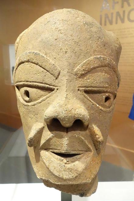
If we understand how words like “tribe” and “stateless society” have been used in the past, then we can avoid perpetuating some of the problematic stereotypes about Africa. Overall, as you read this chapter, keep in mind that Africa has been a continent of innovation and change since the first behaviorally modern humans emerged there between 200,000 and 100,000 years ago. Africans were some of the first farmers and some of the first iron-workers. Africans developed their own artistic traditions (see Figure 9.2, Map 9.3, Figure 9.3) and unique state structures. With such a big, diverse continent to consider, this chapter examines four civilizations (states of larger scale and complexity) to show major changes occurring across the continent. Each of these states was also connected to the rest of the world. The chapter starts with ancient Ethiopia in Northeast Africa (300 to 700 CE) and moves to the Western Sudanic Empires in the Sahel of West Africa (800 to 1591 CE). In the second half, it discusses Great Zimbabwe (1200 to 1450 CE) and, finally, the Swahili states in East Africa (1000 to 1500 CE).

9.6 AKSUM AND ETHIOPIA
Aksum, which was at its most powerful in the fourth through sixth centuries CE, was located in what are today Ethiopia, Eritrea, and parts of Sudan. At its high point, Aksum extended its influence beyond Africa into parts of the southern Arabian Peninsula. It was a great trading empire, with its own coinage, its own language, and its own distinctive Christian church. If you are familiar with accounts of the Queen of Sheba, you know pieces of the story that Ethiopians use to explain the origins of the Ethiopian Solomonic Dynasty and their possession of the Ark of the Covenant. The capital of the kingdom was the city of Aksum, and its most important port was Adulis. The kingdom stretched into the Sudan and Yemen at its height in the sixth century.
Unlike some other regions in Africa, Ethiopia had very fertile, volcanic soils that supported large populations. Climatic variation found at the different elevations throughout Ethiopia also encouraged agricultural diversification and trade. Around 7000 BCE, there was population growth in the region that corresponded with the Agricultural Revolution. While some domesticated animals and crops were introduced from Northeast Africa and the Fertile Crescent, Ethiopians domesticated other crops themselves. Most notably, Ethiopians domesticated teff, a grass, and nsete, known as the “false banana,” that they ground to make bread and porridge. We also have Ethiopians to thank for coffee! Since the Neolithic Revolution, Ethiopia stands out for its agricultural productivity and innovation, both of which sustained large populations in the region.
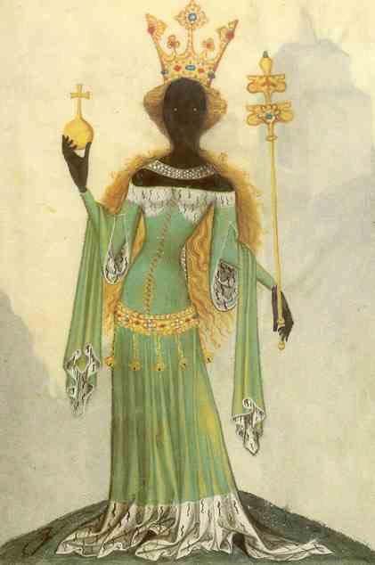
The Kebra Nagast (“The Glory of Kings”), a 700-year-old text that is sacred for Ethiopian Christians and Rastafarians, traces the origins of the Ethiopian royal family back to the Queen of Sheba and King Solomon of Jerusalem. The Kebra Nagast identifies the Queen of Sheba as an Ethiopian ruler known locally as Queen Mekeda. According to the text, in approximately 950 BCE, the newly enthroned Queen Mekeda traveled to study with Jerusalem’s well-known king, King Solomon. Queen Mekeda wanted a capable mentor for leadership advice and spiritual guidance. Charmed by her, King Solomon played these roles and Queen Mekeda, flattered by his attentions, was hardworking and devoted, and eventually converted to Judaism. As their lessons continued, King Solomon planned the seduction of Queen Mekeda, which, as described in the text, occurred when Solomon tricked and cornered her. Their sexual union produced a child, Menelik I, to whom Queen Mekeda gave birth on her journey home to Ethiopia.
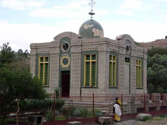
As time passed, King Solomon remained haunted by a dream that Menelik was his rightful successor and was delighted when his son, as an adult, returned to Jerusalem. According to the Kebra Nagast, King Solomon intended for Menelik to follow him as the next king of Jerusalem, but Menelik refused and instead returned to Ethiopia. In an unexpected twist, when leaving Jerusalem, part of Menelik’s entourage stole the Ark of the Covenant, which held the Ten Commandments. When King Solomon discovered the theft, he sent soldiers to recapture the Ark of the Covenant. However, according to the Kebra Nagast, God helped Menelik and his men evade capture by lifting them up over the Red Sea. In the end, Menelik and the Ark of the Covenant made it safely to Ethiopia. For Ethiopian Christians, the Kebra Nagast partially explains the formation of the Ethiopian Orthodox Church (the Tawahedo Church). Through today, the Ethiopian Orthodox Church claims possession of the Ark of the Covenant, which it says is housed in the Church of Our Lady Mary of Zion in Aksum, Ethiopia.
According to the Kebra Nagast, early Ethiopian rulers were descendants of King Solomon through Menelik I. More than two thousand years after King Solomon’s rule, a thirteenth century Ethiopian king, Yekuno Amlak (r. 1270–1285 CE), reclaimed this legacy by tracing his origins back to King Solomon and Queen Mekeda. He founded what became known as the Solomonic Dynasty, which ruled Ethiopia for about 500 years from 1270 to 1769 CE. Members of Ethiopia’s royal family continued to claim descent from King Solomon up through the last Ethiopian emperor, Haile Selassie, who was overthrown in 1974. Therefore, the link back to King Solomon and Queen Mekeda is part of Ethiopian religious beliefs and has also legitimized claims to political power.
From the era of the rule of Queen Mekeda in about the tenth century BCE and Yekuno Amlak’s revival of the Solomonic Dynasty in the thirteenth century CE, the largest kingdoms in Ethiopia were Da’amat and Aksum. The Kingdom of Da’amat was the first to emerge in northern Ethiopia in about the tenth century BCE. Archeological finds show that, by the seventh century BCE, ivory, tortoiseshell, rhino horn, gold, silver, and slaves were brought from interior regions of Africa and traded through Da’amat for imported cloth, tools, metals, and jewelry. Inscriptions, imagery, architectural styles, and even overlaps in historical traditions (such as those associated with the Queen of Sheba) also suggest close connections between the Kingdom of Da’amat and Saba (Yemen) in Southern Arabia. For example, the Kingdom of Da’amat used religious symbols in its monumental architecture, including the disc and crescent, also found in Southern Arabia. The oldest standing building in Ethiopia, the Temple at Yeha (c. 700 BCE), had an altar with these symbols. Up until several decades ago, some scholars used evidence of these connections to argue that people from Saba founded the civilization at Da’amat. Now, in line with the trend to reclaim African civilizations, very vocal scholars push us to acknowledge the African origins of the Kingdom of Da’amat and view it as a precursor to the trading empire of Aksum.
The Kingdom of Da’amat weakened in the fourth century BCE as Red Sea trade became more important than some of the previous northern overland routes. It gave way to the state of Aksum, with its important cities of Adulis and Aksum. Adulis, positioned on the coast, rose in prominence and grew wealthy. It served as a safe harbor for ships traveling from Southeast Asia. The growing capital city in the interior, Aksum, was a stopover point for land-based trade routes into the Sudan and especially Sub-Saharan Africa. Ivory, slaves, tools, spices, gold, silver jewelry, copper, and iron were eventually traded through the capital city of Aksum to the coast. The state of Aksum began minting its own gold and silver coins in the third century CE, demonstrating how important long-distance trade was to its economy.
In addition to its role in inter-regional trade, Aksum was also known for its early conversion to Christianity. Ethiopian tradition traces the establishment of Christianity in the region back to two shipwrecked Syrians. One of the Syrians, Frumentius, was particularly influential because he became the first bishop of Ethiopia in 303 CE and guided the king of Aksum, King Ezana (r. 325–350 CE), in his conversion to Christianity. Some of the coins minted in Aksum actually attest to King Ezana’s conversion, as the coins from the first half of Ezana’s reign have the disc and crescent symbols of earlier Ethiopian rulers, while coins from the later decades of Ezana’s reign have a Christian cross. As bishop, Frumentius also encouraged Christian merchants to settle in Aksum. About a century later, Christianity in Ethiopia grew further as the state offered refuge to Christians fleeing persecution due to doctrinal disputes within the Church. Nine priests, breaking with the Church in Jerusalem, settled in Ethiopia and founded the Ethiopian Orthodox Church. They maintained ties with the Coptic Church in Egypt and developed a distinct liturgy using Ge’ez, the local language. Members of the Ethiopian Orthodox Church also incorporated local beliefs, such as the legendary connection to King Solomon, into their religious traditions.
The ruling family, coastal elites, and military leaders amassed significant wealth during the height of Aksumite power. Like the Aksumite kings before him, Ezana amassed wealth by collecting tribute from surrounding states and taxing trade. Aksum and its surrounding states were agriculturally productive with fertile soils and effective irrigation systems. Their agricultural productivity meant that the work of peasants and the wealth generated through foreign trade supported the ruling classes and elites. Building a powerful military, King Ezana expanded the empire and claimed control over most of Ethiopia, Nubia, and Saba (Yemen). He also used his assets to showcase his power with, for example, “conquest stones” that commemorated his victories. In addition to celebrating Ezana’s military strength and commitment to ruling fairly, the “conquest stones” also proclaimed that God had ordained his reign. The stones impart Ezana’s edicts and Christian beliefs. One section reads:
[…] The Lord of Heaven strengthens my dominion!
And as he now has conquered my enemy, (so)
May he conquer for me, where I (but) go! As
he now has given me victory and has over
thrown my enemies.
(So will I rule) in right and justice, doing no
wrong to the peoples. And I placed
The throne, which I have set up, and the Earth
which bears it, in the protection of the Lord
of Heaven, who has made me king…[8]
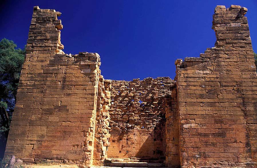
Ezana is known to us because of archaeological findings, including the aforementioned conquest stones. He and other Aksumite kings also famously commissioned the construction of stelae (singular: stele). Stelae were tall rectangular pillars with rounded tops set up to mark the underground grave sites of Aksum’s royalty and elite. The most ornate stelae were elaborately carved into a marble-like material with faux doors at the bottom and multiple stories, as indicated by windows etched into each level. They have been described as “ancient skyscrapers,” with the largest being one hundred and eight feet tall. Most stelae have fallen in the over 1700 years since their construction, but several do remain standing. One stele even caused international uproar as the Italians took it during their occupation of Ethiopia at the onset of the Second World War and recently returned it at great expense.
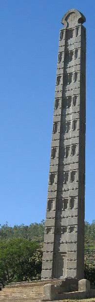
The stelae demonstrate the wealth of Aksum’s ruling classes and links between the ruling generations. Unfortunately, the graves marked by the stelae have been cleared out by tomb robbers in the intervening years. However, small remnants of glass, pottery, furniture, beads, bangles, earrings, ivory carvings, and objects gilded in gold attest to the wealth buried with affluent Aksumites. These artifacts also show the availability of trade goods brought from long distances. Furthermore, the architecture of the stelae is suggestive of connections back to earlier kingdoms. For example, the rounded top of the stelae is reminiscent of the disc symbol found in the region as far back as the Kingdom of Da’amat. Ezana was the first Christian king in the region; however, the architecture that he commissioned maintained ties to Aksum’s pre-Christian past.
Aksum’s power began to wane at the end of the sixth century CE. First, the Persian Empire interrupted Aksum’s trade with parts of southern Arabia in the late sixth century. Then, Muslims increasingly dominated trade along the Red Sea coast, and the most profitable trade routes shifted from the Red Sea to the Persian Gulf. In response, Aksum shrank as Ethiopia’s Christian rulers turned away from coastal trade and became more dependent on the tribute they collected from agriculturally productive regions to their south.
As Muslims in coastal areas became more powerful and Christian rulers shifted their attentions away from the coast, the relationship between Ethiopian Muslims and Christians remained complex. In the seventh century CE, one king of Aksum, al-Najashi Ashama Ibn Abjar, gave sanctuary to some of the first followers of Islam before he himself converted. In subsequent years, Muslims traders and Christian elites oftentimes cooperated. For example, from the tenth through fourteenth centuries, Muslims set up trading settlements in the interior that facilitated the conspicuous consumption of Christian elites who desired imported goods. However, there were also periods of conflict, especially after Muslims unified to form the Adal Sultanate in the fourteenth century. The Adal Sultanate militarily extended its influence over much of the region and for several centuries supported a thriving, multi-ethnic state. In the sixteenth century, Ethiopian Christians allied with the Portuguese to fight against the Adal Sultanate. After the fall of the Adal Sultanate, Ethiopian Christians rejected Portuguese attempts to convert them to Catholicism and forced Portuguese missionaries out of the region in 1633 CE.
9.7 THE WESTERN SUDANIC STATES
Who comes to mind as the richest person ever? Many economists and historians propose a person who might surprise you: Mansa Musa. Mansa Musa was an emperor in the Western Sudan during the Middle Ages. He was so rich that the people of his own time could not even fathom his wealth. Unable to put a dollar amount on Mansa Musa’s bewilderingly large fortune, Rudolph Ware, historian of Africa and Islam, instructs us to “imagine as much gold as you think a human being could possess and double it...”[9] Other sources estimate that, adjusted for inflation, Mansa Musa was worth $400 billion.[10] How did Mansa Musa become so wealthy? Like the other Western Sudanic African rulers, he controlled much of the world’s access to gold during a period when gold was in very high demand.
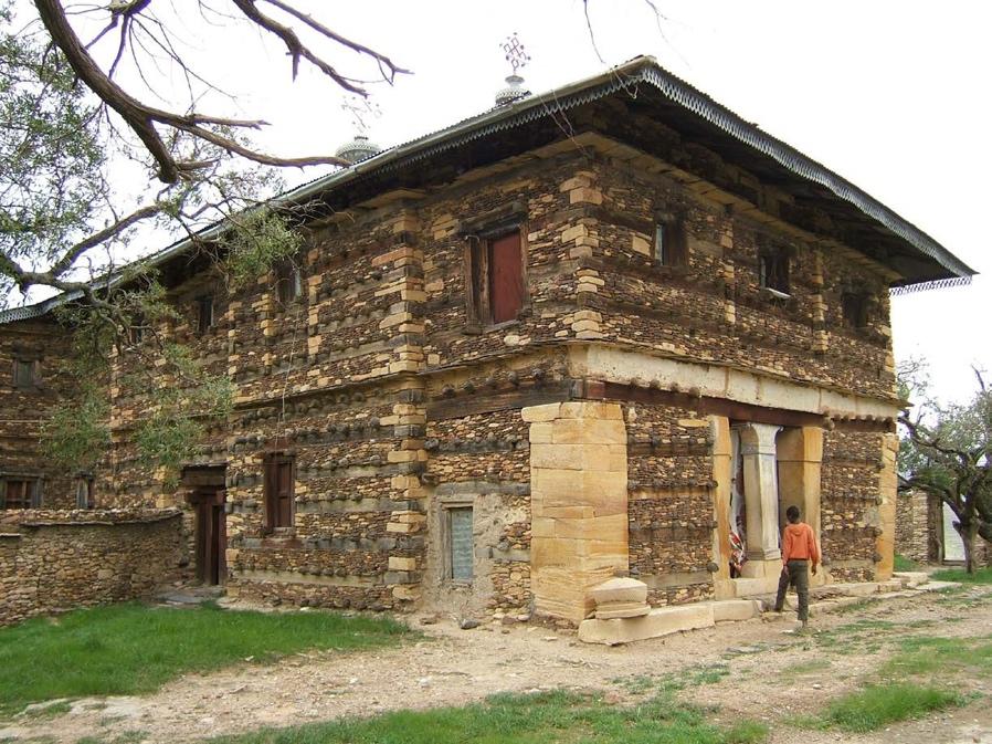
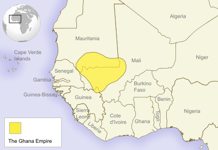
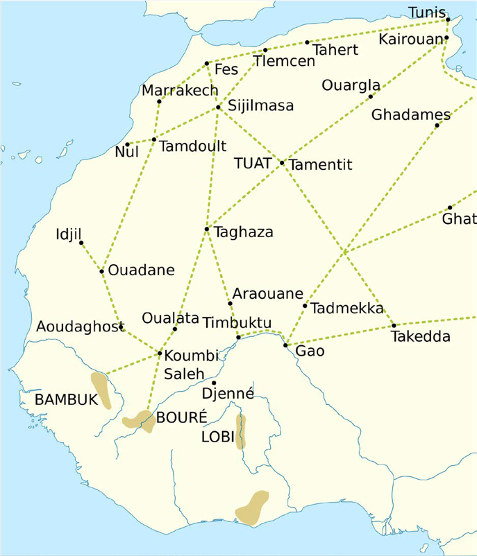
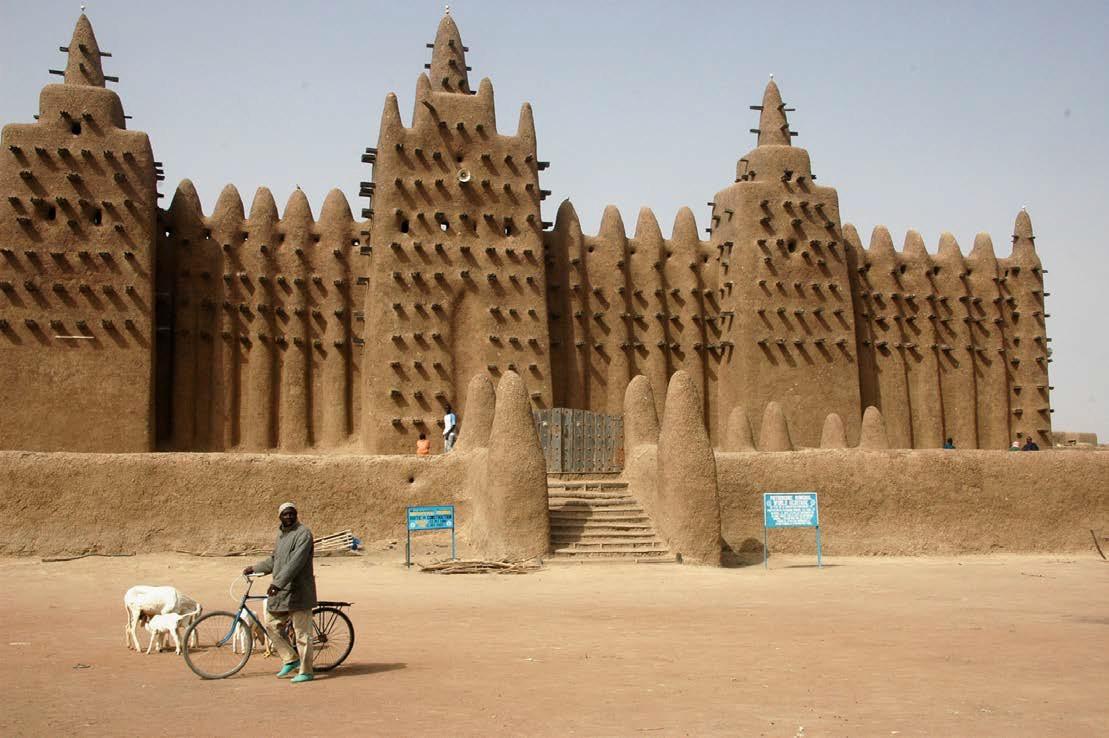
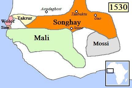
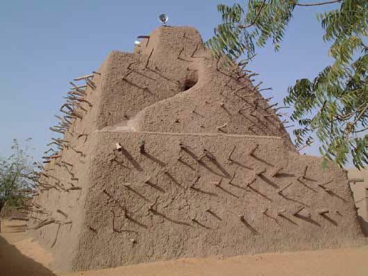
Map 9.4 shows the large area in West Africa commonly referred to as the Western Sudan. The Western Sudan does not correspond with a modern-day African country; instead, it is a region. Arabic-speaking travelers gave the region its name, calling it bilad-al-Sudan or the “Land of Blacks.” The Sahel, which in Arabic means “the shore,” is a transition zone between the Sahara Desert to its north and the more forested regions to its south. Much of the Sahel is grassland savannah. Straddling regions with different climates, the people of the Western Sudan developed productive agriculture, trade networks, and an urban culture. The architecture of the Western Sudanic states stands out for its use of mud (adobe) to construct its monumental buildings, such as the Great Mosque in Djenne (Figure 9.9) and Askia the Great’s tomb in Gao (Figure 9.11). From roughly 800 to 1600 CE, the people of this region organized and supported—sometimes under duress—the large states that dominated the Western Sudan. Three of the best known of these states became the empires of Ghana (800–1070s CE), Mali (1230s–1430s CE), and Songhai (1460s–1591 CE).
The leaders of Ghana, Mali, and Songhai came to dominate the region because they controlled access to West African gold. An increase in the demand for West African gold corresponded with the rise of these empires. The spread of Islam and rise of new states along the North African coast and in Europe gave the biggest boost to the demand for gold. To meet the demand, Berber traders used newly introduced camels to carry gold north across the desert. Then, they loaded up their camels with big slabs of salt to return south. The people in many parts of West Africa considered salt a valuable commodity due to their distance from the ocean and the time required to extract salt from plant, animal, and other resources. While the demands for gold and salt drove the trade, weapons, manufactured goods, slaves, textiles, and manuscripts also passed through the desert. With the flow of all of these goods, the Western Sudanic states emerged at the nexus of the trans-Saharan trade routes. The North African Berber traders crossing the Sahara Desert were early converts to Islam, and they introduced Islam to market towns of the Western Sudanic states. With continuing trade, the region’s connections with Northeast Africa and the Middle East grew through the Middle Ages. Growing urban areas, like Timbuktu, attracted Muslim scholars. In later centuries, the kings of Mali and Songhai deliberately fostered these connections with the larger Islamic World due to their religious beliefs and, sometimes, to enhance their status and secure their positions. For example, Askia Muhammad, the king of Songhai from 1495 to 1528, successfully sought recognition as the “caliph of Sudan” from Egyptian rulers. The new title brought him prestige within the Islamic World and Africa. Therefore, trans-Saharan trade brought Islam to the Western Sudan, and many of the kings of Mali and Songhai cultivated their relationships with Muslims in Northeast Africa and the Middle East. As a result, Islam influenced the culture and lifestyle, particularly of urban residents, in the Western Sudan.
9.7.1 Ghana
We associate the first powerful empire, Ghana (800–1070s CE), with people who spoke the Soninke language and lived in the area between the Niger and Senegal Rivers—parts of present-day Mauritania and Mali. In this region, agricultural productivity supported labor specialization, urban areas, and eventually state formation. From as early as 300 BCE, the region’s farmers used iron tools to grow an abundance of crops, including rice, millet, and vegetables. Iron technologies also allowed craftsmen to make iron spears and swords so people could protect themselves. Probably for defense purposes, Soninke speakers began joining together to form the ancient state of Ghana around 300 CE. Then, as the populations continued to grow, the state expanded its territory.
Even before Ghana was a state with a clearly defined centralized administration, Soninke speakers had been involved in extensive systems of trade using the region’s complex river systems. They often acted as middlemen, trading in fish from the rivers, meat from herders, and grains from farmers. After 300 CE, Ghanian leadership began collecting tributary payments from neighboring chiefdoms. In the centuries that followed, Ghana’s leaders used their ability to tax trade to build an empire. By 800 CE, they had consolidated their control over trade, their authority over urban areas, and their reign over tributary states.
Especially in the minds of the Arab scholars chronicling the history of this period, the gold trade defined Ghana. They heard about the large caravans with hundreds of camels passing through the Sahara Desert on their way to and from Ghana. To build their fortunes, the Ghanian kings taxed trade goods twice. They taxed gold when it was initially brought from the forested regions in the south to their market towns and again right as the Berber traders departed for the north. News of Ghana’s wealth spread to the extent that Medieval Arab scholars who had never even traveled to Africa wrote about the Ghanian kings. In one manuscript, Al-Bakri, an eleventh-century geographer based in Muslim Spain, described how a Ghanian king was adorned in gold and guarded by dogs wearing gold and silver collars. According to Al-Bakri, the king demonstrated his power having his subjects “fall on their knees and sprinkle dust on their heads” upon entering his presence.[11] The kings shored up their power through their ostentatious displays of gold and their monopoly over trade. Al-Bakri recognized the centrality of gold to the finances of the Ghanian kings. According to him, the kings claimed all of the gold nuggets for themselves, leaving only gold dust for everyone else. By this time, the Ghanian kings had also used their wealth to build strong armies, with archers and calvary, to collect tribute and carry out the empire’s expansion.
Al-Bakri’s depiction of Ghana’s capital city, Koumbi Saleh, also evidences the introduction of Islam to the region. He described two separate sites within the capital city, Koumbi-Saleh. To trade their wares, the merchants used one site, which was clearly Muslim with mosques, while the king lived in a royal palace six miles away. The separation between the sites and lack of mosques near the royal palace suggest that Islam had primarily impacted the market towns; the leadership and masses of Ghana did not convert.
9.7.2 The Mali Empire
Due to attacks from the Muslim Almoravids from the North, issues with overgrazing, and internal rebellions, Ghana declined in the eleventh century, opening up an opportunity for the rise of Mali. The origins of the Mali Empire (see Map 9.7) are associated with the king Sundiata Keita (c. 1217–1255 CE). An epic, recounted orally by griots for centuries and written down in various forms in the twentieth century, relates the story of Sundiata’s rise. One version written by Guinean D. T. Niani in 1960 follows Sundiata as he overcomes a number of challenges, like being unable to walk until he is seven years old, being banished by a cruel stepmother, and facing tests given by witches. With loyal followers and the attributes of a born leader, Sundiata overcomes these and other challenges in the epic to found the new empire. Under Sundiata, some of Mali’s leadership converted to Islam; however, even with conversion, they maintained important pre-Islamic traditions. The epic demonstrates the prevalence of syncretism or the blending of religious beliefs and practices in West Africa. For instance, the epic traces Sundiata’s background back to Bilali Bounama, one of the early followers of the Muslim prophet Muhammad, and the powerful pre-Islamic local clans of the lion and the buffalo. According to oral tradition, Sundiata’s ability to draw from both Muslim and traditional African sources of strength allows him to overcome adversity and defeat his less worthy opponents.
Like Sundiata, most of the subsequent kings of Mali combined Muslim and local religious traditions. For example, they often completed the “Fifth Pillar” of Islam by performing the hajj, the pilgrimage to Mecca required of all able Muslims. In the meanwhile, they continued to use pre-Islamic amulets, maintain their animistic beliefs, and consider pre-Islamic sacred sites to be important. Similarly, when they converted, the people living within Mali’s cities and those involved in trans-Saharan trade also blended Muslim and traditional beliefs and practices.
Sundiata built the Mali Empire in the thirteenth century, and the empire reached its height under Mansa Musa (c. 1280–1337 CE) in the early fourteenth century. Through diplomacy and military victories, Sundiata swayed surrounding leaders to relinquish their titles to him. Thus, Sundiata established a sizeable empire with tributary states and became the mansa, or emperor, of Mali. Most of the subsequent mansas of Mali maintained their control over the gold-salt trade, the basis of their wealth. Mali also developed a more diversified economy and was recognized in Europe, North Africa, and the Middle East as a prosperous trading center.
Mansa Musa, who was likely Sundiata’s grandson or grandnephew, further developed the empire and made it one of the crossroads of the Medieval Islamic World. Mansa Musa used a large army of approximately 100,000 soldiers to reunify the empire after several tumultuous decades. Under Mansa Musa, Mali stretched much farther east, west, and south than had its predecessor kingdom, Ghana. Farmers specialized in regional crops, and the state operated farms where slaves grew food for the royal family and the army. Mansa Musa also developed the empire’s administration, dividing the territory into provinces and appointing competent governors.
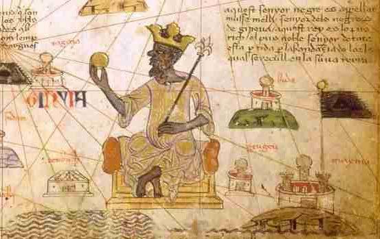
With all of these achievements, Mansa Musa is best remembered for going on the hajj from 1324 to 1325 CE. He attracted a great deal of attention traveling in a huge caravan made up of almost 100 camels, 12,000 slaves, and an estimated 30,000 pounds of gold. Local lore claims that he gave out so much gold during his three-month stay in Cairo that the price of gold dropped by 25%. Likewise, reportedly, after he passed through Alexandria, the value of gold in the city stayed low for a decade. Mansa Musa’s impressive display in Northeast Africa and the Middle East boosted Mali’s standing in the Islamic World. After his return to Mali, Mansa Musa further cultivated Islamic connections by building new mosques and schools. He hosted Muslim scholars and made cities, including Timbuktu, Djenne, and Gao, into centers of learning. Mansa Musa also encouraged the use of Arabic, and the libraries, especially of Timbuktu, became repositories of Islamic manuscripts. The Catalan Atlas (Figure 9.10) demonstrates Mansa Musa’s preeminence. Commissioned by Charles V of France, the 1375 map shows Mansa Musa ruling his empire. He sits atop a gold throne, wearing a gold crown, carrying a gold scepter, and gauging (or perhaps admiring) a gold nugget. Awash in gold in the Catalan Atlas, Mansa Musa paid for his various projects by collecting tribute from surrounding states and taxing trans-Saharan and inter-regional trade.
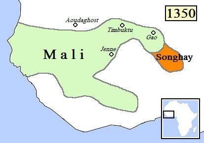
Several factors, including weak leadership, foreign invasions, and rebellions within the tributary states, led to the decline of Mali after Mansa Musa’s death. The empire lost territory throughout the early fifteenth century. With the decline of Mali, leaders in one of its breakaway tributary states, Songhai (alternatively spelled Songhay), expanded militarily and encroached on Mali’s territory. By the late 1460s, when he captured Timbuktu, Songhai’s leader Sunni Ali had begun to build a new empire, the Songhai Empire, through military conquest.
9.7.3 Songhai
The Songhai Empire is most closely associated with the Sorko people who lived alongside the Niger River, southeast of Gao. By about 800 CE, the Sorko had created their own state, Songhai, trading along the river and building a military that used war canoes. With the growth of trans-Saharan trade and eventually the discovery of new gold fields, the Sorko and other ethnic groups in the area established market towns in Songhai. Most of the people who moved to these market towns converted to Islam by the eleventh century. In the early fourteenth century, the Mali Empire collected tribute from Gao, though other parts of the Songhai state remained independent. Using his military to pick off pieces of Mali in its waning years, Sunni Ali built the Songhai state into an empire in the 1460s.
During its Golden Age, the Songhai Empire was ruled by Askia Mohammad I (r. 1493–1528). Referred to as Askia the Great, Askia Mohammad I was a devout Muslim, who centralized the empire’s administration, encouraged agriculture, and further expanded the state. Askia rose to power as the general-in-chief of the army of Gao. He won a military victory over Sunni Ali’s son to found a new dynasty, the Askia dynasty. As a devout Muslim, Askia went on the hajj to Mecca from 1496 to 1497. The pilgrimage brought him international recognition and reinforced his claims to power especially because the Sharif of Mecca bestowed Askia with the title “the Caliph of the Sudan.” Upon his return, Askia used Islam to validate attacks on neighboring states, like the Mossi in 1498. He also rebuilt Islamic centers. Leo Africanus, originally from Granada (Spain), traveled through Timbuktu in 1526 and wrote,
[…] There are in Timbuktu numerous judges, teachers, and priests, all properly appointed by the king. He greatly honors learning. Many hand-written books imported from Barbary [the coastal regions of North Africa] are also sold. There is more profit made from this commerce than from all other merchandise. [12]
Under Askia, Timbuktu, Djenne, and Gao, once again, beckoned scholars and people with commercial aspirations. Taxing gold remained an important source of revenue for the king, but trade expanded to incorporate items such as manuscripts, kola nuts, prisoners of war (who were sold as slaves), horses, and cowry shells (which were used as an internal currency). Additionally, to centralize his administration, Askia appointed loyal Muslim governors to new provinces, replacing hereditary rulers. After his death, Askia’s sons, particularly his last son, Askia Dawud (r. 1549–1582 CE) continued to generate wealth by taxing trans-Saharan trade. Like their father, they also tended to invest in Songhai’s Islamic centers. For example, during the reign of Dawud, there were approximately one hundred and fifty Islamic schools operating in Timbuktu. Askia Dawud’s death in 1582 saw the reemergence of power struggles amongst competing rulers and rebellions within tributary states, signaling the end of the Golden Age of Songhai.
Then, the biggest blow to the crumbling Songhai Empire came from the invasion by Morocco in 1591. The Moroccan army used new technology, muzzle-loading firearms, to defeat the Songhai troops. The Songhai state limped along until 1737, but after 1591, it was no longer a unified empire with control over numerous tributary states. For almost 1,000 years, large empires had dominated the Sahel. The leaders of Ghana, Mali, and Songhai, each in turn, taxed trans-Saharan trade and grew powerful. They built their empires with urban centers, strong militaries, and numerous tributary states. However, the Moroccan invasion eroded their power. Furthermore, the Age of Exploration, begun by the Portuguese in their progress down the West Africa coast in the fifteenth century, redirected trade. Trans-Saharan trade diminished and was largely replaced by trade up and down the Atlantic coast of West Africa.
9.8 THE SPREAD OF AGRICULTURE AND GREAT ZIMBABWE
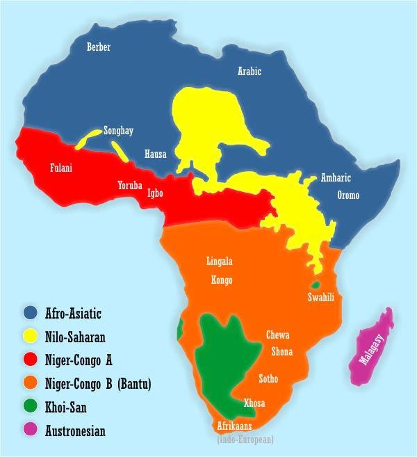
Most of the languages indigenous to Africa belong to one of the major language groups shown in Map 9.9. Over the past several decades, historians of Africa have started to pay more attention to these language groups. They use comparisons of core vocabulary words in related languages to examine the spread of ancient technologies and the interaction between peoples. Using linguistics (the study of languages), historians corroborate information found in other sources, like oral traditions of dynastic origins and archaeological findings.
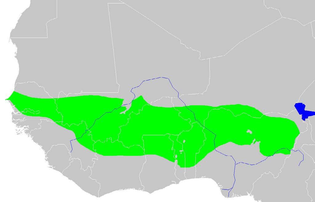
Today’s scholars are not the first ones to notice linguistic similarities on the continent. During European colonization one hundred and fifty years ago, anthropologists grouped Africans into “tribes” based on presumed physical, cultural, and linguistic similarities. They found that people in most of Sub-Saharan Africa spoke languages that used the root –ntu to refer to person, with the prefix ba added in the plural. Combining the root and the plural prefix, nineteenth-century colonial anthropologists referred to people in these communities as Bantu and later traced Bantu languages back to a root, a mother language spoken in parts of Cameroon and Nigeria. To explain the similarities in the languages, European scholars hypothesized that about 2,000 years ago, there was a Bantu Migration, a massive departure of thousands of Bantu speakers from the Bantu homeland. As they described, Bantu speakers imposed iron technology and traditions of agriculture on the peoples they encountered in eastern and southern Africa. Influenced by their own conceptions of colonization, nineteenth-century anthropologists incorrectly portrayed the Bantu Migration as a rapid conquest of Sub-Saharan hunter-gatherer societies by the technologically advanced, Iron Age Bantu speakers.
Since the 1990s, historians of Africa have used linguistics to reject some pieces of the nineteenth-century description of the Bantu Migration. Referring instead to Bantu expansions, they generally agree that the movement of Bantu speakers was more of a slow diffusion of languages and technologies that lasted about 4500 years, from roughly 3000 BCE to 1500 CE. Bantu speakers took multiple routes, and sometimes their movement occurred on the scale of a single family, as opposed to a mass of thousands. From the linguistic evidence, historians also suspect that both Bantu speakers and those they settled amongst contributed ideas and technologies; there was mutual “teaching and learning from one another.”[13] The current view of the Bantu expansions is much more complex as it recognizes give and take between Bantu newcomers and indigenous populations. For example, some indigenous populations rejected Bantu languages, while others repackaged Bantu technologies incorporating their own innovations. There was no Bantu migratory conquest of indigenous communities. Instead, the study of linguistics seems to confirm that Bantu languages, iron-working, and agriculture slowly spread through eastern and southern Africa in the early centuries CE.
These corrections are important because they allow scholars to much more accurately discuss state formation in southern and southeastern Africa. In the colonial era, European scholars sometimes jumped to misleading conclusions when they encountered evidence of early African states. For example, in 1871, when the German geographer Carl Maunch saw the ruins of an impressive civilization, Great Zimbabwe, he concluded that people from Yemen must have built the grand structures. Biased by nineteenth-century racism, Maunch assumed that Africans were incapable of statehood and the skilled masonry techniques evident at Great Zimbabwe. Subsequent Europeans reached similar conclusions upon viewing the site, attributing the civilization to Phoenicians and Arabs. Some white supremacists in southern Africa clung onto this fabricated history of Great Zimbabwe’s foreign origins until the early 1990s.
In the meantime, a number of scholars had confirmed the African origins of Great Zimbabwe. Archaeologists showed that Great Zimbabwe had features, like stone masonry and rituals involving cattle, found in nearby African kingdoms. Historians used oral tradition and linguistics to track African state formation in the region and show that Great Zimbabwe was a Bantu civilization. Archaeologists and historians concluded that from approximately 1200 to 1450 CE, Great Zimbabwe was the thriving commercial and political center of a rich southern African state.
During the Middle Ages, a prosperous elite based in Great Zimbabwe ruled over about 300 settlements on the Zimbabwe Plateau. Great Zimbabwe and the linked settlements had similarly constructed walled enclosures, practiced mixed farming (they grew crops and kept livestock), and used iron, copper, and bronze. The 300 settlements paid tribute in the form of ivory, gold, cattle, and crops to the rulers in Great Zimbabwe. The wealth generated through the collection of tribute helped Great Zimbabwe become a center of trade and artistry. Great Zimbabwe exported gold and ivory to cities like Sofala and Kilwa Kisanwani, on the East African coast. From the coast, these goods were carried to the Persian Gulf, India, and China. In exchange, Great Zimbabwe’s elite imported luxury items like stoneware, colored glass beads, and cotton. Out of these imports, artisans based in Great Zimbabwe made jewelry, ornaments, and cloth for elite consumption.
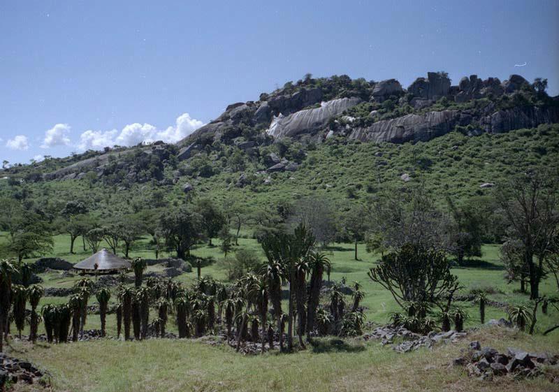
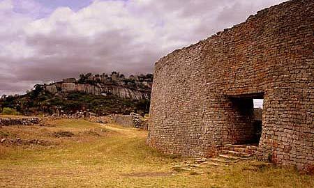
The architectural evidence of Great Zimbabwe’s social hierarchies is one of the most dramatic elements of the site’s ruins. Covering three square miles, the ruins of Great Zimbabwe consists of many clusters of stone buildings. The most famous structures are the Hill Complex (Figure 9.13) and the Great Enclosure (Figure 9.12). The stone buildings were constructed with local granite, and the stones were stacked without mortar, a process known as ashlar masonry. Scholars hypothesize that the ruling elite resided and performed ceremonies on the Hill Complex, symbolically demonstrating their authority with the height and separation of the complex. From about 1300 CE, more than 15,000 people lived in the valley below them in small, circular homes with thatched roofs and walls made of clay and gravel. The Hill Complex overlooked a number of other structures, including the famous Great Enclosure. With its stone walls up to thirty-five feet tall, the Great Enclosure was the largest structure in precolonial Sub-Saharan Africa. The Great Enclosure was a ceremonial site, perhaps used by religious leaders or as a site for the initiation of youth. Scholars disagree about its exact function but suggest that the Great Enclosure further demonstrated the status and wealth of the capital city and the ruling classes.
Great Zimbabwe declined in the fifteenth century and was abandoned by 1450 CE. Some scholars suggest that the site deteriorated because it was supporting up to 30,000 people and thus became too crowded, deforested, and stripped bare of resources through overuse. Surrounding gold mines may have also been depleted. In any case, trade shifted to support the rise of two new kingdoms, Batua to the west and Mutapa to the east. Both kingdoms built stone walls like those seen in Great Zimbabwe and practiced mixed agriculture, using cattle for ceremonies and as symbols of the ruling elite’s power. From the fifteenth through seventeenth centuries, the kingdoms also faced the Portuguese and the influx of other African populations. The Mutapa Kingdom lasted the longest, enduring until 1760. Overall, this rewritten history of southern and southeastern African statehood acknowledges the significance of the Bantu expansions that brought agriculture and iron to many regions. It also celebrates the African origins of great civilizations and demonstrates how Africans shared technologies and cultural practices across the Zimbabwean plateau.
9.9 THE SWAHILI CITY-STATES (EAST AFRICA)
In the tenth century CE, a grand Persian sultan, Sultan Ali ibn Sulaiman al-Shirazi, sailed to Kilwa Kisiwani, an island off the East African coast. When he arrived, he was generous and people liked him, which enabled him to marry the daughter of Mrimba, the local headman. The newlyweds were set up to live more or less happily ever after. However, Sultan Ali and Mrimba made a deal, brokered by Mrimba’s daughter. The deal gave Sultan Ali control of the island in exchange for enough cloth for Mrimba to “walk on it from the island to his new abode on the mainland.”[14] The deal went through, and Mrimba moved to the mainland, but then Mrimba regretted relinquishing his position and plotted to militarily retake the island from his son-in-law. In response, Sultan Ali used magic from the Qur’an to stop Mrimba’s plot. By reading the Qur’an in a special way, Sultan Ali kept the sea levels high, which confined Mrimba to the mainland, where he gave up and retired. Upon Mrimba’s death, his mainland territory passed to the son of Sultan Ali who also ruled Kilwa Kisiwani. In this oral tradition, the union of Mrimba’s daughter and Sultan Ali forged a new Muslim family, with Persian and African ancestry, that ruled Kilwa Kisiwani and the mainland coast.
The above version is just one account of Kilwa Kisiwani’s origins; nevertheless, it conveys some very important elements of Swahili identity. Starting at least by the thirteenth century CE, in response to resident Arab merchants who scorned non-Muslims and some African practices, African elites in East Africa claimed descent from Shirazis (Persians) and to have been early converts to Islam. In some cases, the connections may have been exaggerated or inaccurate from a historical standpoint. However, regardless of their accuracy, these stories demonstrate some of the defining features of Swahili identity.
As it controlled gold coming from Great Zimbabwe, Kilwa Kisiwani became one of the most prosperous of the Swahili city-states. From 1000 to 1500 CE, Swahili city-states were wealthy urban areas connected to both the African interior and the larger Indian Ocean World. Dozens of Swahili city-states running down the East African coast from Mogadishu to Sofala, and including islands off the coast, were commercial centers, tied together by a shared identity, not an overarching political structure. In addition to Islam and claims to Persian ancestry, Swahili identity also became associated with Indian Ocean trade, an urban style, and a shared language (Swahili).
Historians of Africa trace the origins of the Swahili city-states to the Bantu expansions, explaining that by the first century CE, Bantu farmers had built communities along the East African coast. They traded with southern Arabia, southeast Asia, and occasionally Greece and Rome. Although trade contracted after the fall of the Roman Empire, it rebounded several hundred years later. At that time, residents of the Swahili city-states played a pivotal role as middlemen, selling gold, timber, ivory, resins, coconut oil, and slaves from the interior regions of Africa to traders arriving from throughout the Indian Ocean World. In return, Swahili elites bought imported glass, porcelain, silk, spices, and cloth. The seasonal monsoon winds that allowed trade between the Swahili coast and southern Arabia, the Persian Gulf, and southeast Asia also facilitated cultural exchange. Blowing towards the East African coast three to four months of the year and reversing several months later, the monsoon winds stranded traders for months at a time, encouraging intermarriage and cultural exchange. Furthermore, the wealth of the Swahili coast attracted Persian and Arab immigrants. With African, Arabian, and southeast Asian influences, Swahili culture became a blended culture as, for example, the Swahili language incorporated loan words from Arabic and Hindi.
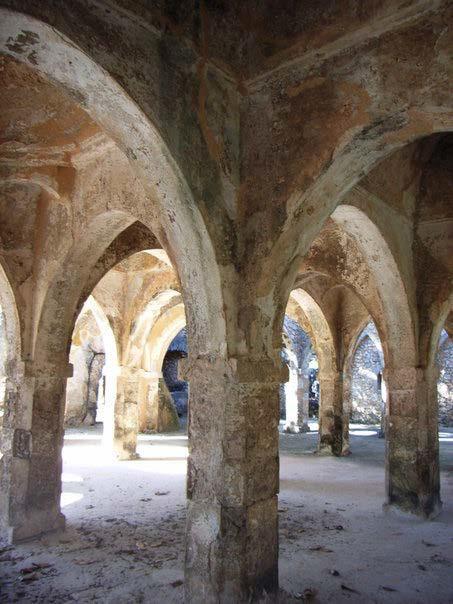
One of the quintessential features of the Swahili city-states from 1000 to 1500 CE was their urban style. A few families made up the elite, ruling classes, while most people in the cities were less wealthy, working as craftsmen, artisans, clerks, and sailors. People in villages along the coast could also identify as Swahili. Claimants of Swahili identity spoke the Swahili language and were Muslim. Archaeology shows that emerging Swahili cities had mosques and Muslim burial grounds starting in the eighth century CE. By their height, the Swahili city-states were distinctly Muslim; they had large mosques built of local coral stone. The Swahili, regardless of their economic status, drew a distinction between themselves as Muslims and the “uncultured,” non-Muslim Africans of the interior.
The elite families played a role in fashioning Swahili urban style. In addition to tracing their descent back to some of the earliest Muslim settlers from Persia, they embraced Islam, financing mosques, practicing purdah (the seclusion of women), and hosting large religious celebrations. Their Muslim identity stimulated trade, as visiting Muslim merchants felt comfortable extending credit to them and living with their Swahili host families while waiting for the winds to turn. By 1350 CE, the urban style of Swahili city-states exhibited a distinguishing architecture. Many of the cities became “stone towns” with wealthy Swahili families constructing multi-level homes out of the coarse coral. The Swahili elite used their stone houses to establish themselves as prominent, creditworthy citizens. They wore imported silk and cotton and ate off imported porcelain to further display their status. Like other Swahili, the ruling classes distinguished themselves from non-Muslims of the interior. They may have been partially moved to draw this distinction by their desire to sell humans as slaves who were captured in the neighboring, non-Muslim communities.
Slavery within the Indian Ocean World, the zone of contact and interaction connecting people living adjacent to the Indian Ocean, began well before the spread of Islam in the seventh century CE. During the high point of the Swahili city-states, Muslim traders controlled the slave trade within the Indian Ocean World. Slaves tended to be captives of war sold to the Arabian Peninsula and regions near the Persian Gulf. Slaves were put to work as sailors, agricultural laborers, pearl divers, domestic workers, concubines, and musicians. Our information about the everyday lives of slaves in this region is very limited.
In one famous revolt, slaves from East Africa (the Zanj), who were forced to work on sugar plantations and salt flats near Basra (in present-day Iraq), seriously challenged the power of the Abbasid Caliphate in the 9th century. Led by Ali ibn Muhammad, the Zanj rose up in the Zanj Rebellion, a guerrilla war against the Abbasids. For fourteen years, the Zanj and their supporters, altogether an estimated 15,000 people, raided towns, seized weapons and food, and freed slaves. They captured Basra and came within seventy miles of Baghdad, the Abbasid capital. The rebels created their own state with fortresses, a navy, tax collection, and their own coinage. At enormous cost, the Abbasids finally put down the revolt in 883 CE using a large army and by offering amnesty to the rebels. Scholars have used the Zanj Rebellion to examine the scope of the Indian Ocean trade in East African slaves, the conditions of slavery in the Indian Ocean World, and the agency (the ability to exert their own will) of slaves. Some of these scholars suggest that the Zanj Rebellion led Muslims in Arabia to largely abandon the practice of using East African slaves as plantation laborers. The rebellion helps them explain why the Indian Ocean slave trade developed differently than the trans-Atlantic slave trade.
While there were some similarities between the trans-Atlantic trade that brought slaves to the Americas and the slave trade within the Indian Ocean World, there were important differences. Both slave trades took Africans, contributing to an African diaspora, or a dispersal of African peoples and their descendants, all over the world. The trans-Atlantic slave trade, which lasted approximately 300 years and reached its peak in the eighteenth century CE, forced approximately 12 million people, mostly from West Africa, into the Americas. The slave trade within the Indian Ocean lasted much longer, about 2000 years, and was generally smaller in scale but still involved roughly 10 million. Scholars suggest that African slaves in the Indian Ocean World had more social mobility, especially since many of them were skilled soldiers. Also, according to Islamic precepts, slaves had some basic rights and could be incorporated into the households that they served. Theoretically, a freeborn Muslim could not be enslaved. Unlike slavery in the Americas, slavery within the Indian Ocean World was not racially codified, so freed slaves did not automatically face racial discrimination. And due to their reproductive capacities, women were more sought after as slaves within the Indian Ocean World, while the trans-Atlantic slave trade had the highest demand for young men. Despite these general trends, there was great individual variation within the slave experience.
Moving up the East African coast in the late fifteenth and early sixteenth centuries, the Portuguese sacked some Swahili cities and tried to tax trade. In 1498, when they happened upon the Swahili coast, the Portuguese were trying to establish a direct sea route to the riches of India and China. After using an East African guide to reach India, the Portuguese began to set up a Trading Post Empire, which intended to tax trade within the Indian Ocean. The Trading Post Empire consisted of a series of forts along the Indian Ocean coast where Portuguese administrators collected taxes and issued trade permits. In the early 1500s, the Portuguese returned to the Swahili city-states to enforce their will. As the Swahili city-states did not have a unified political structure or large armies, the Portuguese successfully looted and destroyed some Swahili cities. However, the Portuguese cultural influence and their ability to enforce tax collection was very limited north of Mozambique. The Portuguese did not move inland beyond the coastal cities, and by and large, trade within the Indian Ocean continued without a great deal of Portuguese interference. However, the Portuguese presence encouraged Swahili leaders to ally with the Omanis from southern Arabia. In 1699, the Omanis, working with some Swahili rulers, seized Mombasa from the Portuguese and began an era of Omani dominance of the Swahili coast.
9.10 CONCLUSION
These African states showcase the continent’s connections to the rest of the world, a multitude of African innovations, and the importance of using a variety of methodologies to interrogate long-held assumptions about Africa. Africa was not isolated. Instead, oceans and deserts were “highways” in these periods. Aksum, the Western Sudanic states, Great Zimbabwe, and the Swahili coast were all commercially linked to Europe, the Mediterranean, the Arabian Peninsula, the Persian Gulf, southeast Asia, and even China. Although there were local differences, the ruling classes in each of the states collected tribute from outlying areas and participated in long-distance trade. The wealth of these states supported labor specialization, urbanization, and other innovations.
African states contributed to great cultural change. As just one case in point, Ethiopia, the Western Sudanic states, and the Swahili city-states all experienced religious transformations. Not only did Ethiopia serve as a sanctuary for both Christians and Muslims, but Ethiopians also established their own Church, the Ethiopian Orthodox Church. Starting in the thirteenth century CE, Western Sudanic rulers converted to Islam, maintaining some of their pre-Islamic beliefs while building their connections with the rest of the Islamic World. Medieval African cities like Timbuktu benefitted from these connections. They attracted traders as reports of African gold circulated far and wide. Taxing the gold trade, Western Sudanic rulers developed these cities as both trading depots and places of scholarly learning. The Swahili in coastal East Africa also embraced Islam as one of the defining features of their identity. Their urban style reflected the centrality of Islam, which they believed distinguished them as cultured and refined. All four states also developed numerous other innovations, such as those in art, architecture, metal-working, agriculture, and political organization.
Before the twentieth century, foreigners recorded much of Africa’s written history. There are limitations to their accounts, meaning that a number of written documents about Africa are misleading, at best. Many African societies remembered their own histories orally, using professionalized classes of historians, storytellers, and musicians, in addition to proverbs and the teachings of elders. Over the past fifty years, historians of Africa have done more to incorporate Africa’s oral traditions into their examination of the ancient past. They have also used linguistics and archaeology to create a more accurate written history of the continent and reclaim African civilizations.
9.11 WORKS CONSULTED AND FURTHER READING
Ali, Omar. Islam in the Indian Ocean World: A Brief History with Documents. Boston: Bedford/St. Martin’s, 2016.
Asante, Molefi Kete. The History of Africa: The Question for Eternal Harmony. 2e. New York: Routledge, 2015.
Brizuela-Garcia, Esperanza and Trevor Getz. African Histories: New Sources and New Techniques for Studying African Pasts. Boston: Prentice Hall, 2012.
Center for Food Security and Public Health. “African Animal Trypanosomiasis.” College of Veterinary Medicine, Iowa State University. 2009 http://www.cfsph.iastate.edu/Factsheets/pdfs/trypanosomiasis_ african.pdf
Collins, Robert O. and James Burns. A History of Sub-Saharan Africa. Cambridge: Cambridge University Press, 2007.
Conrad, David. “Oral Tradition & Perceptions of History from the Manding Peoples of West Africa.” In Themes in West Africa’s History. Ed. Emmanuel Kwaku Akyeampong. Athens, Ohio: Ohio University Press, 2006: 73-96.
Ehret, Christopher. The Civilizations of Africa: A History to 1800. Charlottesville, VA: University Press of Virginia, 2002.
Garlake, Peter. Early Art and Architecture of Africa. Oxford: Oxford University Press, 2002.
Gilbert, Erik and Jonathan Reynolds. Africa in World History: From Prehistory to the Present. 3e Upper Saddle River, NJ: Pearson, 2012.
Hall, Martin. Farmers, Kings, and Traders: The People of Southern Africa, 200–1860 Chicago: University of Chicago Press, 1990.
Horton, Mark and John Middleton. The Swahili. Oxford: Blackwell Publishers, 2000.
Keim, Curtis. Mistaking Africa: Curiosities and Inventions of the American Mind. 3e. Boulder, CO: Westview Press, 2013.
Kingdom of Aksum. http://www.earlheinrich.com/Ancient%20Nubia/Aksum_Empr-Map-72dpi.jpg.
Marcus, Harold. A History of Ethiopia. Berkeley: University of California Press, 2002.
Niane, D.T. Sundiata: An Epic of Old Mali. Trans. G.D. Picket. Harlow, England: Pearson Longman, 2006.
Nurse, Derek and Thomas Spear. The Swahili: Reconstructing the History and Language of an African Society, 800–1500. Philadelphia: University of Pennsylvania Press, 1985.
Ranger, Terence. “The Invention of Tradition in Colonial Africa.” In The Invention of Tradition. Ed. Eric Hobsbawm and Terrence Ranger. 211-262. Cambridge University Press, 2012.
Shillington, Kevin. History of Africa. 2e. Oxford: Macmillan Education, 2005.
UNESCO. “Tomb of Askia.” http://whc.unesco.org/en/list/1139
Wiley, David. “Using ‘Tribe’ and ‘Tribalism’ to Misunderstand African Societies.” http://www.africa.upenn. edu/K-12/Tribe-and-tribalism-Wiley2013.pdf
- Quoted in “The East Coast of Africa: Duarte Barbosa,” Aspects of World Civilization, vol. 1, Ed. Perry M. Rogers, (Upper Saddle River, NJ: Prentice Hall, 2003): 376. ↵
- Ibid, p. 377. ↵
- African Language Program, Department of African and African American Studies, “African Languages,” Harvard University, http://aaas.fas.harvard.edu/greetings-director-african-language-program. ↵
- World Health Organization Media Centre, “Yellow Fever: Fact Sheet,” http://www.who.int/mediacentre/factsheets/fs100/en ↵
- Quoted in Ann Badkhen, Walking with Abel: Journeys with the Nomads of the African Savannah (New York: Riverhead Books, 2015): 20. ↵
- “Growth Areas: the urbanisation of Africa,” Economist (Dec. 13, 2010), ↵
- Christopher Ehret, The Civilizations of Africa: A History to 1800 (Charlottesville, VA: University Press of Virginia, 2002): 7. ↵
- As quoted in Esperanza Brizuela-Garcia and Trevor Getz, African Histories: New Sources and New Techniques for Studying African Pasts (Boston: Prentice Hall, 2012): 33-36. ↵
- Jacob Davidson, “The 10 Richest People of All Time,” Time (July 2015) ↵
- “Musa’s Money.” BBC. http://www.bbc.co.uk/programmes/p02f9r6g ↵
- Quoted in “Kingdom of Ghana: Primary Source Documents.” African Studies Center. Boston University Pardee School of Global Studies. http://www.bu.edu/africa/outreach/k_o_ghana ↵
- “Leo Africanus: Description of Timbuktu.” From The Description of Africa (1526). http://public.wsu.edu/~brians/world_ civ/worldcivreader/world_civ_reader_2/leo_africanus.html ↵
- As quoted in Brizuela-Garcia, Esperanza and Trevor Getz, African Histories: New Sources and New Techniques for Studying African Pasts. Boston: Prentice Hall, 2012: 43. ↵
- John Middleton, The World of the Swahili: An African Mercantile Civilization, (New Haven: Yale University Press, 1994): 31-32. ↵
