1.2 The Environment and Human Activity
Learning Objectives
- Explain how climate and human habitation are related and distinguish between the main climate types.
- Explain the dynamics of tectonic plates and their relationship to earthquakes and volcanic activity.
- Outline the main causes of and problems with deforestation. Explain the relationship between deforestation and climate change.
- Point out where the rain shadow effect takes place and explain why it occurs in those places and how it may influence human activity.
- Understand how climate change occurs and the relationship between greenhouse gasses such as carbon dioxide and the planet’s temperature regulation
Climate and Human Habitation
The reception of solar energy is a primary factor in determining surface temperatures, and thus has a big impact on human populations. For instance, there are no human communities in Antarctica because it is so cold. Answering the basic questions of where most humans live on Earth and why they live there depends on understanding climate.
More than 70 percent of the earth’s surface is covered with water. However, less than 3 percent of the water is fresh, and most of that is stored in ice caps in the Arctic and Antarctic. This leaves less than 1 percent of the world’s fresh water for human use, which is usually in lakes, rivers, streams, or groundwater and underground aquifers. Climate plays an important role in where humans live because precipitation is necessary for growing crops, raising livestock, and supplying fresh water to urban communities.
In many regions of the globe, migratory storm systems significantly influence the lifestyles of human populations. Abrupt variations in temperature and intense precipitation events accompany migratory frontal systems that generally travel west to east across the middle latitudes (such as the continental USA and Canada). These can cause blizzard conditions in winter. At lower latitudes, warm oceans spawn hurricanes, called typhoons or simply cyclones in different parts of the globe. These often penetrate the middle latitudes after formation and, upon landfall, can cause catastrophic damage.
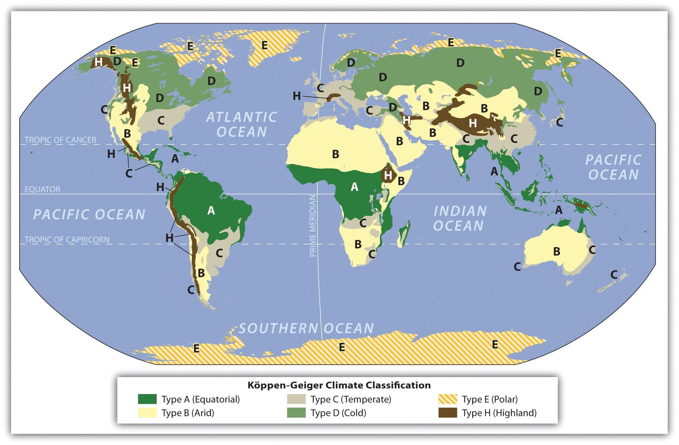
Several geographers have endeavored to classify the world’s climates into climate types. Climate can be defined as a long-term average weather pattern evident in a particular region of the world. Weather is instead a term usually used to define current conditions. The two main elements in climate conditions are temperature and precipitation. For the purposes of this global overview, the various climate types have been broken down into six basic types—A, B, C, D, E, and H—after the Köppen-Geiger classification system. Type H climates are actually a subset of the type E climate category.
- Type A: Tropical or equatorial climates
- Type B: Dry or arid climates
- Type C: Moderate or temperate climates
- Type D: Cold or continental climates
- Type E: Polar or extreme climates
- Type H: (Unclassified) highland climates
Type A: Tropical or Equatorial Climates
The humid tropical type A climate, usually found in the tropics, has warm temperatures year-round with a high level of precipitation, typically in the form of rain. Type A climates have various subgroups that indicate how variably the rainfall is distributed throughout the year. Some type A climates produce a dry season and a wet season (including monsoons), while others receive consistent rainfall throughout the year.
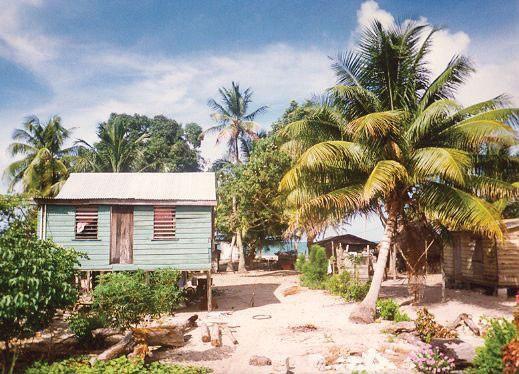
rainfall, such as this location in coastal Belize. “Tropical Climate A” by Royal Berglee is licensed under a Creative Commons CC BY-NC-SA 4.0..
Type B: Dry or Arid Climates
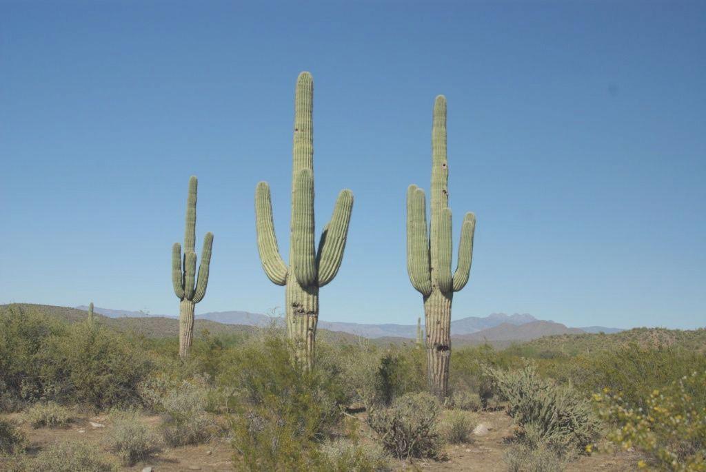
The dry type B climate is exemplified by the earth’s desert regions. Temperatures can be extreme, with little precipitation. Type B climate regions experience low rainfall and high temperatures during the day and cooler temperatures at night or during the winter season. Landscapes in type B climates can range from sand deserts to short prairie grasslands or steppes. Type B climates have fewer trees than most other climate areas.
There is a direct relationship between highlands and type B climates in various places in the world, especially in the form of dry areas existing downwind of mountains. This rain shadow effect is evident wherever there is terrain with enough elevation to restrict the movement of precipitation-bearing clouds, pinning them on the upwind side of a mountain range. It is also true that mountainous areas have more precipitation than flatlands, overall.
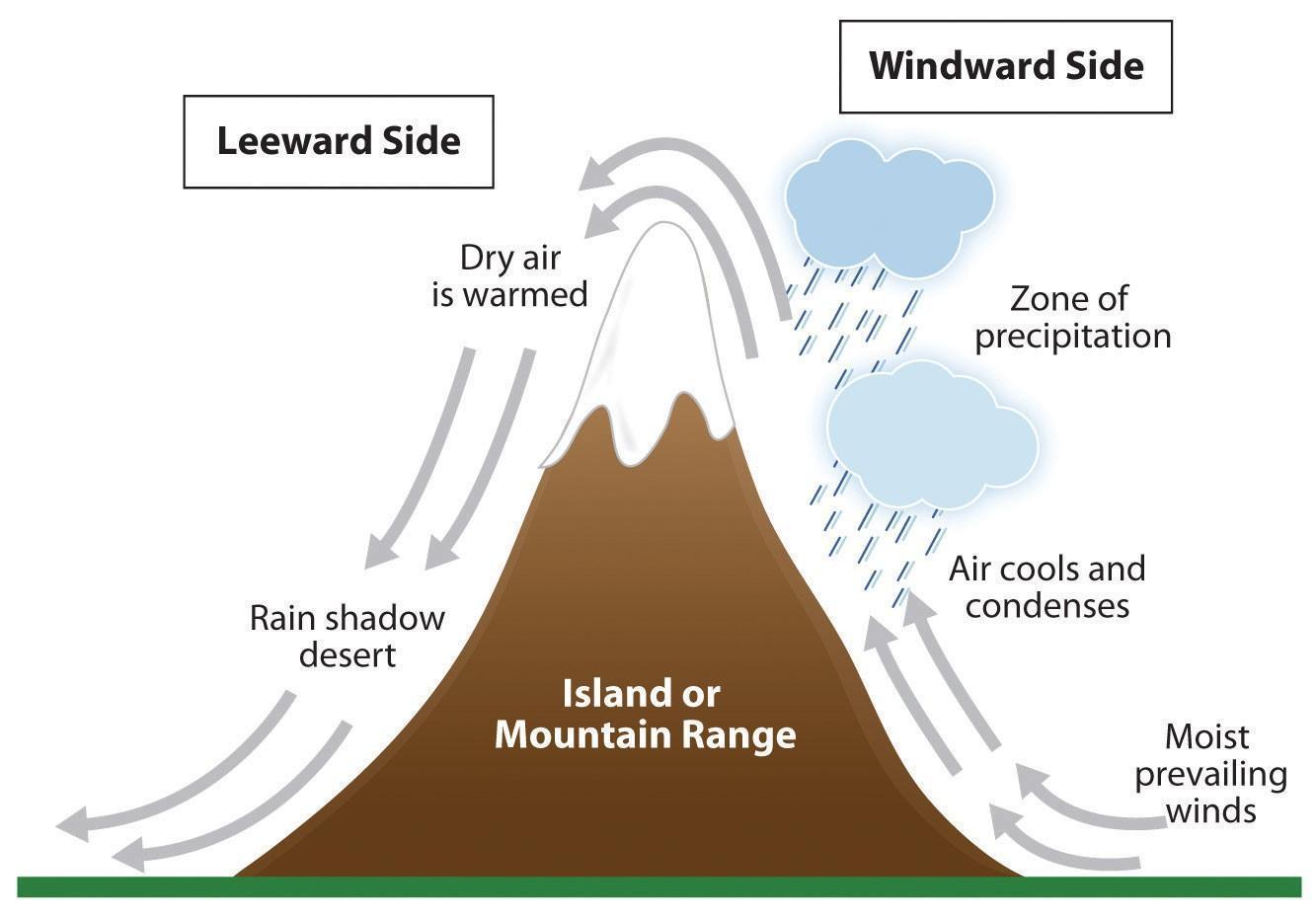
Rain shadows are created when prevailing winds carrying moisture ascend as they are deflected over a mountain mass, where the air cools and condenses to precipitate out its moisture in the form of rain or snow. The dried air descends the other side of the mountain range, where it increases in temperature. The warm, dry air coming off the mountains results in arid climate conditions, extending beyond the mountains themselves
The Hawaiian island of Kauai has an extreme example of the rain shadow effect. The island’s windward side receives more rain than almost any other place on Earth: as much as 460 inches (almost 40 feet) a year. Only a part of the island, however, receives that amount of rain. The height of the mountains causes a rain shadow on the dry leeward side, creating semidesert conditions and type B climates.
Death Valley in California is also a result of the rain shadow effect. Little rain falls on Death Valley because moisture in the prevailing winds falls in its ascent of the upwind Sierra Nevada mountain ranges. Indeed, the whole state of Nevada is dry because of this rain shadow. On the other side of the earth, most of western China has type B climates because of the rain shadow effect caused by the very high Himalayan mountains that stop rain clouds from reaching the region from the Indian Ocean to the south. Western China is sparsely inhabited compared with the high-density regions in China Proper to the east, where rainfall is plentiful.
As profound as the influence of mountains may be on precipitation, some other factors are also important. Because rising air is a necessary ingredient for forming clouds and precipitation, areas of chronically sinking air tend to be arid. This is the case for many areas around the 30th parallel of latitude, both north and south of the equator—such as the Sahara and Arabian Deserts or those of Arizona. Cold ocean currents can also keep air from rising (cold air touching the ocean surface resists rising), producing coastal deserts such as those in Chile and Peru of South America. Finally, areas far inland, such as the interior of Asia, can be dry because of their remoteness from oceanic moisture sources.
Type C: Moderate or Temperate Climates
Often described as moderate in temperature and precipitation, type C climates host the largest human population densities on the planet. Type C climates are found mostly in the midlatitudes, comparable to the position of the continental USA and southern Canada. Seasonal changes are pronounced, with distinct winters and summers. Precipitation varies from low to high, depending on location.
Type D: Cold or Continental Climates
Type D climate regions are often found in the interiors of continents away from the moderating influence of large bodies of water. They are generally farther north than type C regions, resulting in colder winters. Seasonal variations are pronounced, with cool to hot summers contrasting with very cold winters. Precipitation is usually in the form of rain in summer and snow in winter. Type D climates can be found in much of Canada and Alaska and a large portion of Russia.

Type E: Polar or Extreme Climates
Type E is an extreme climate type found in the polar regions. Type E climates are cold with permanent ice or permafrost. Where bare ground is available, vegetation is still minimal, and there are no trees. Temperatures may warm slightly during the short summer months but rarely rise above 50 degrees.
Type H: Highland Climates
Type H highland climates are usually listed as a subcategory of type E climates. The decline of temperature with elevation in mountain ranges can create climate zones that become progressively colder at higher elevations. In extreme cases, tropical type A climates may exist at the base of a mountain, and ice-capped E climates at the summit, with intermediate climates occupying elevational zones in between. Mountain climates are also notoriously changeable, creating their own clouds and rainfall, strong winds, and abrupt temperature shifts. Sunlight is intense, and the air atop high mountains is thin.

Biome
Vegetation is a significant component of any landscape. As a general pattern, forests are found naturally where there is sufficient moisture and warmth for tree growth, while drier and colder climates have shorter vegetation. The world’s ecosystems are commonly divided into eight basic types. Tropical areas that are perpetually warm and wet have Tropical Rain Forests of tall, broad-leaved (vs. needle-leaved) trees that keep their foliage the year round. Tropical areas that have a dry season, instead have grassland interspersed with trees: the Tropical Savanna biome. The driest conditions of the low and midlatitudes are occupied by Desert, where bare soil exists between shrubs and/or cacti. In the middle latitudes, moist areas are occupied by broad-leaved Midlatitude Deciduous Forests that drop their leaves for winter. In large areas of the southeastern USA, natural fires kept these forests in a perpetual state of pine domination—including in most of Louisiana. Drier midlatitudes are occupied by treeless Midlatitude Grasslands—a biome that has largely been converted to crop and grazing land. A relatively restricted biome found in some coastal lower midlatitude areas, such as southern California, is the shrubby and fire-prone Chaparral. In cool climates like those of Canada, the dominant biome is the needle-leaved Boreal Forest, while approaching the Arctic, the treeless Tundra takes over.
Deforestation
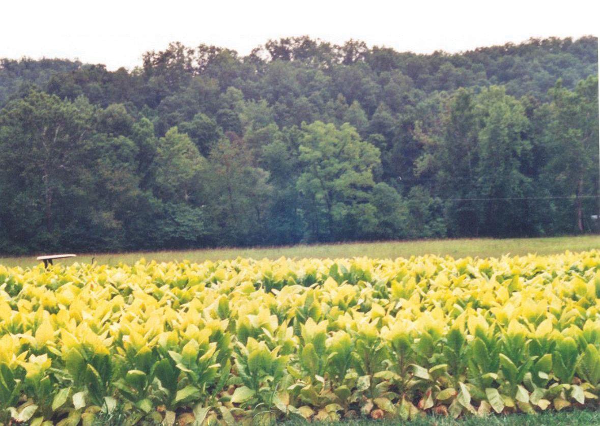
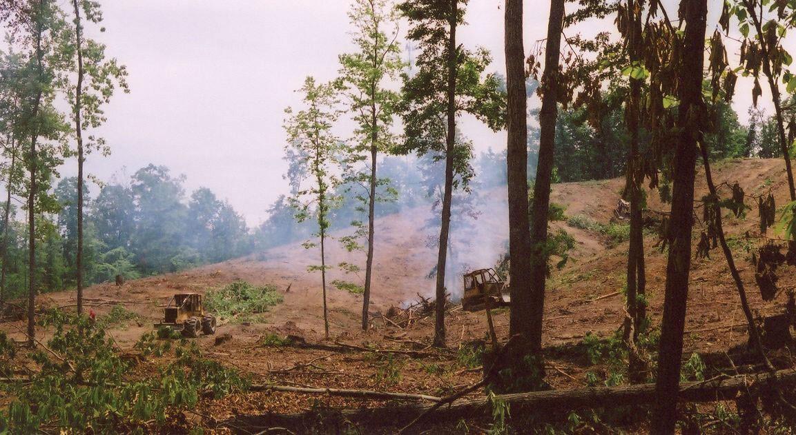
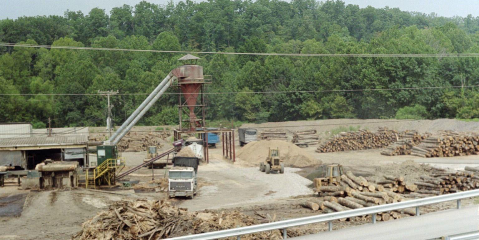
The planet’s growing population has increased demands on natural resources, including forest products. Humans have been using trees for firewood, building homes, and making tools for millennia. Trees are a renewable resource, but deforestation occurs when they are removed faster than they can be replenished. Most people in rural areas in developing countries rely on firewood to cook their food. Many of these areas are experiencing a fast decline in the number of trees available. People living in mainly type B climates may not have access to a lot of trees to start with; therefore, when trees are cut down for firewood or for building materials, deforestation occurs. In the tropical areas, it is common for hardwood trees to be cut down for lumber to gain income or to clear the land for other agricultural purposes, such as cattle ranching. Countries that lack opportunities and advantages look to exploit their natural resources—in this case, trees—for either subsistence agriculture or economic gain. Deforestation has increased across the globe with the rapid rise in worldwide population.
During the Industrial Revolution, European countries chopped down their forests at a rapid rate. Much of the British Isles was forested at one point, but today few forests remain on the British Isles, and they are typically protected. Colonialism brought the Europeans to the Americas. The United States, in its early development, pushed west from the original thirteen colonies, and many old growth forests were cut down in the process. As railroad tracks were laid down and pioneer development pushed west into the Great Plains, where there were few trees, the great cutover occurred in the eastern and central forests—cutover is a term indicating the systematic deforestation of the eastern and central forests. Michigan and Wisconsin saw their trees removed in a systematic deforestation.
Some areas were allowed to grow back, but many other areas were turned into farmland. Few old-growth forests remain in the United States. Today there are conflicts over how the timber industry is handling the forests in places such as the Pacific Northwest region of the United States.
Countries that are better off economically no longer have to cut down their own trees but can afford to substitute other resources or import lumber from other places. Developing regions of the world in Latin America, Africa, and parts of Asia are experiencing serious problems with deforestation. Deforestation is widespread: Residents of Haiti have cut down about 99 percent of the country’s forests; most of the wood has been used as fuel to cook food. People in Afghanistan have cut down about 70 percent of their forests. Nigeria has lost about 80 percent of its old-growth forests since 1990. Ethiopia has lost up to 98 percent of its forested acreage, and the Philippines has lost about 80 percent of its forests.
Brazil’s Amazon basin has undergone many projects that have driven deforestation. For example, about half the state of Rondônia in western Brazil has been deforested since 1990. The countries of Central America have lost about half their original forests, and deforestation continues on a systematic basis. Tropical regions of Southeast Asia and Africa are being exploited for their timber at unsustainable rates, causing deforestation that the next generation will have to deal with. India, with over a billion people, still has a high demand for firewood and building materials; their forests are declining faster than they can be replanted. China, with its billion plus population, has been attempting to address its deforestation problems by implementing a massive replanting program and conservation measures. Other countries are starting to adopt similar measures.

Tropical rain forests only make up about 5 percent of the earth’s surface but contain up to 50 percent of the earth’s biodiversity. These forests are cut down for a variety of reasons. Norman Meyers, a British environmentalist, estimated that about 5 percent of deforestation in tropical regions is caused by the push for cattle production. Nineteen percent of these forests are cut down by the timber industry, 22 percent are cut down for the expansion of plantation agriculture, and 54 percent are removed due to slash-and-burn farming. Most tropical rain forests are located in the Amazon basin of South America, in central Africa, and in Southeast Asia. All these areas are looking for advantages and opportunities to boost their economies; unfortunately, they often target their tropical rain forests as a revenue source.
What Are the Problems with Deforestation?
Deforestation causes more than the loss of trees for fuel, building materials, paper products, or manufacturing. Another related issue in the deforestation equation is soil erosion. Without the trees to hold the soil during heavy rains, soils are eroded away, leaving the ground in an unproductive state. In tropical areas, soils are often degraded and lack nutrients. Most of the nutrients in the tropical areas rest in decaying material at the base of the trees that supplies energy back into the ecosystem. Once the trees are removed, there is little replenishing of this energy supply. Soil erosion in tropical areas makes it hard for forests to grow back once they have been removed. Landslides can be a more severe component of the soil erosion problem. After heavy rainfall, entire hillsides saturated with water can slide downward, causing serious structural damage to buildings, homes, and agricultural plots. Tree roots help hold hillsides together and therefore help prevent landslides.
Forests play an important role in the water cycle. Trees pull up moisture with their roots from the soil and transpire it through their leaves back into the atmosphere. Moisture in the atmosphere collects into clouds, condenses, and falls back to Earth. Not only do trees store water, but organic matter at the base of the trees also stores water and makes it available to the larger ecosystem, which may slow down water runoff. Forest canopies disperse water during rainfall and create another layer of moisture in their leaves and branches, which either is used by other organisms or evaporates back into the atmosphere. Deforestation eliminates the role that forests play in the water cycle.
Forest ecosystems provide for a diverse community of organisms. Tropical rain forests are some of the most vibrant ecosystems on the planet. Their abundant biodiversity can provide insight into untapped solutions for the future.
Plants and organisms in these habitats may hold the key to medical or biological breakthroughs, but wildlife and vegetation will be lost as deforestation eliminates their habitat and accelerates the extinction of endangered species.
Trees and plants remove carbon dioxide from the atmosphere and store it in the plant structure through the process of photosynthesis. Carbon dioxide is a major greenhouse gas that is a part of the climate change process. Carbon dioxide and other similar gases reduce the amount of long-wave radiation (heat) that escapes from the earth’s atmosphere, resulting in increased temperatures on the planet. As more carbon dioxide is emitted into the atmosphere, climate change occurs. The removal of trees through deforestation results in less carbon dioxide being removed from the atmosphere, which contributes to climate change. Slash-and-burn farming methods that burn forests release the carbon in the plant life directly into the atmosphere, increasing the climate change effect.
Climate Change
Climate change has been a constant activity in the planet’s evolution. The increase in temperature in our environment is the activity that has gained the most attention in recent years. Questions have been raised about the rate and extent of climate change around the world. Understanding the dynamics of the temperature increase can assist in understanding how it is related to human activity.
The atmosphere is the gaseous layer that surrounds the earth and marks the transition between its surface and space. The atmosphere consists of a mixture of gases, composed of nitrogen (77 percent), oxygen (21 percent), and minor elements (1 percent) including argon, helium, carbon dioxide, and water vapor. The small amount of carbon dioxide is a critical component in the control of the earth’s temperature. The atmosphere extends over three hundred miles above the earth’s surface, and the lower level makes up the earth’s climatic system. This lowest level is called the troposphere and is responsible for the conditions that allow life to exist on the planet’s surface.
Since the 1960s, scientists have been concerned about the concentrations of carbon dioxide, methane, nitrous oxide, and chlorofluorocarbons in the atmosphere. These so-called greenhouse gases can trap heat energy emitted from the earth’s surface and may increase global temperatures and cause climate change. Since the Industrial Revolution, human activity—the burning of fossil fuels and large-scale deforestation—has increased the amount of heat-trapping greenhouse gases in the atmosphere. Carbon dioxide and similar gases act like the glass panels of a greenhouse that allow shortwave radiation from the sun to enter but do not allow the long-wave radiation of heat to escape into space.
An increase in carbon dioxide and greenhouse gases in the atmosphere will normally cause an increase in the temperature of the planet’s climate, which in turn may cause changes in weather conditions in various places on Earth. Temperature changes may affect precipitation patterns and alter weather patterns, which may affect agricultural outputs and influence energy needs that can create increasing economic instability. Changes in climate also impact environmental conditions for organisms adapted to specific habitat ranges. When climates change, an organism’s habitable zone may also change, which in turn can impact entire ecosystems.
Deforestation and the burning of fossil fuels can contribute to climate change. Fossil fuels such as coal, oil, and natural gas are created when dead plant and animal life are under pressure, decay for long periods, and retain their carbon component. Burning fossil fuels releases the carbon back into the atmosphere. The increasing need for energy and lumber by human activity will continue to contribute to climate change unless alternatives can be found. The increase in temperatures may result in the melting of the ice caps, which in turn may raise sea levels, impacting human activity around the world. More information about climate change is included in chapter 13 on Antarctica.
Tectonic Plates
Dynamic processes that determine the configuration of earth’s surface geology have profound influences on human populations. The study of processes that shape the land surface is a prominent pursuit of physical geographers, called geomorphology. The movement of tectonic plates is the largest scale aspect of this. The earth’s crust, which is between 10 and 125 miles thick, is not one big solid chunk but rather a series of plates that cover a molten iron core at the center of the planet. The plates that cover the earth’s surface slowly shift and move. Plates can slide away from each other or they can collide, and they can slide parallel to each other in opposite directions. When two plates collide and one plate slides under an adjacent plate, the process is called subduction. Movement or shift where two plates meet can cause earthquakes and is usually associated with volcanic activity.

Mountain chains, such as the Himalayas, are a direct result of two plates colliding. The collision pushes up the earth into a mountain chain, either by direct pressure or by volcanic activity. Plates can move up to an inch a year in active regions. Driven by the earth’s internal heat, these plates have created the planet’s mountain landscapes. Earthquakes and volcanic action along plate boundaries (called faults) continue to affect human activity and can cause serious economic damage to a community. Plate boundaries can be found near many natural edges of continents. The continuous action of the plates causes serious earthquakes and volcanic eruptions that can devastate human activities. Earthquakes near the sea often trigger tsunamis that can create enormous waves that bring destruction to coastal regions in their path. The earthquake off the east coast of Japan in 2011 created a tsunami that brought additional destruction to nuclear energy facilities, exposing parts of Japan to radiation.

Other Geomorphic Processes
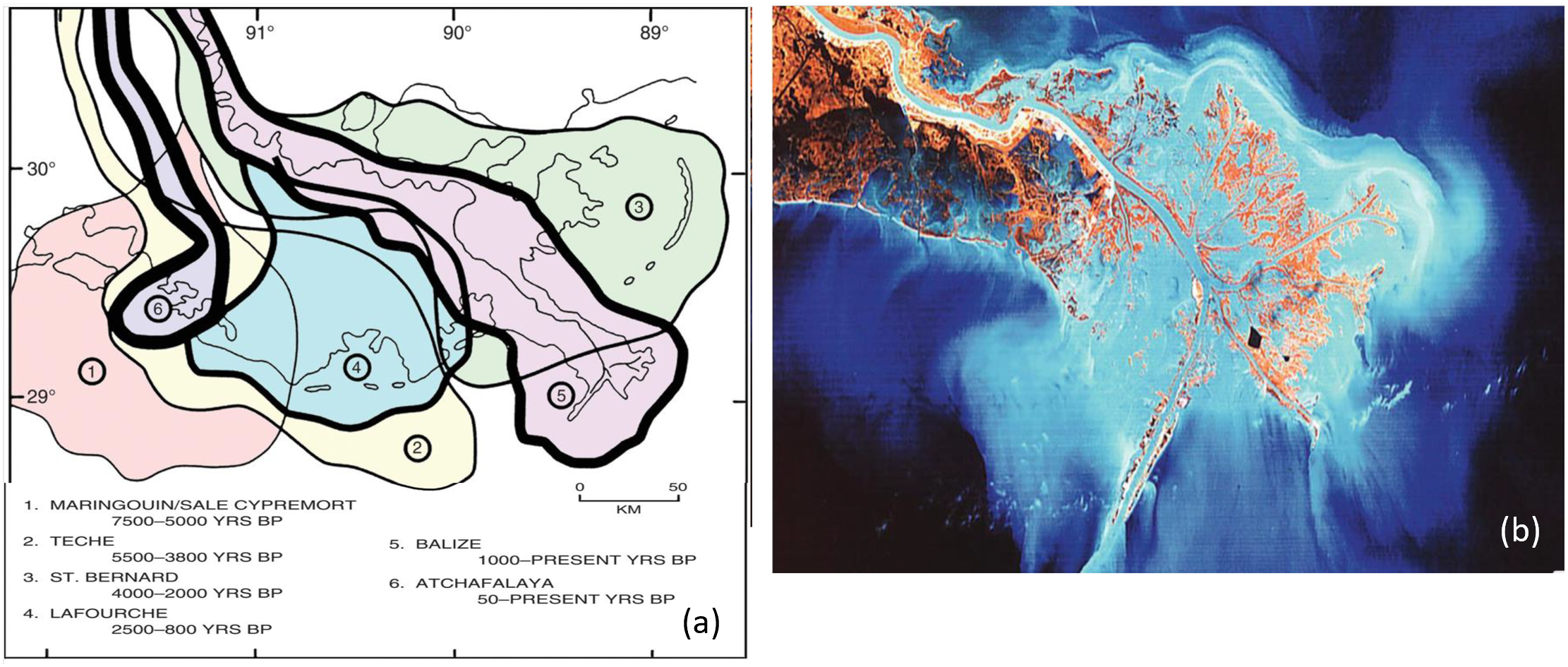
The land surface is constantly being reshaped by erosion, and by accumulation of the eroded sediments after they are moved by running water and other forces. In Louisiana, the hilly terrain north of Baton Rouge known as the Tunica Hills, is an accumulation of eroded sediments wind-blown from the Great Lakes area. Of special importance to humans is the process by which rivers create flat land along their channels or where they enter oceans. Rivers carve paths for themselves through the surface bedrock. As they shift and wind laterally over time, the carved area becomes broad and fills with flat alluvial (water deposited) sediments to form a flat floodplain. Floodplains have long been favored for human habitation, providing flat surfaces for transportation routes and farming, and convenient access to water. Likewise, where rivers dump sediment from their mouths, they can build broad, flat deltas. In Louisiana, the Mississippi River is flanked by prominent floodplains, and has built several deltas in the various places it has entered the Gulf of Mexico. New Orleans is located on one such delta. Unfortunately, floodplains and deltas can be prone to flooding when rivers rise or storms push water onshore—as happened infamously to New Orleans in Hurricane Katrina in 2005.
Key Takeaways
- Human activity on the planet correlates with the types of climate and terrain that present themselves to humans in the form of natural resources or habitability. Six basic climate zones (A, B, C, D, E, and H) describe the earth’s climate types. Temperature and precipitation are the two main variables that create a climate zone and its corresponding environmental attributes.
- The earth’s crust consists of a number of separate plates that move, creating earthquakes and volcanic activity. Most mountain ranges on Earth are products of tectonic plate activity.
- Removing trees faster than they can grow back is called deforestation. Humans are cutting down the forests in many areas at an unsustainable rate. Deforestation can result in soil erosion, changes in weather patterns, and the loss of habitats. Trees are being cut down for firewood, building materials, or profit.
- Mountains or high elevation relief can restrict the passage of rain clouds and cause the clouds to lose their precipitation as the air mass increases in elevation. The other side of the mountain or range does not receive any precipitation and is reduced to a more arid or drier region, creating desert conditions.
- Climate change is a phenomenon whereby gases such as carbon dioxide and methane increase in the troposphere and restrict long-wave radiation from escaping the planet, which can result in warmer temperatures on Earth. Trees remove carbon dioxide from the atmosphere, which may reduce climate change.
Discussion and Study Questions
- What climate type do you live in?
- What are the main attributes of each climate type?
- What two main climatic qualities do humans gravitate toward?
- What is the difference between weather and climate?
- How can the main causes of deforestation be alleviated or diminished?
- What are tectonic plates, and how do they help shape the planet?
- How would tectonic plate movement affect human activities?
- Who is responsible for addressing the problems caused by climate change? What can you do about it?
- What causes a rain shadow effect? Name some examples of this phenomenon.
- Which regions of the planet are being affected the most by deforestation?
Activities
- Research and determine when the last three earthquakes nearest where you live occurred. What damage did they cause?
- Chart the annual average temperature for where you live for the past one hundred years to illustrate any trend in climate change.
- Determine the nearest location to where you live that is impacted by a rain shadow effect.
