2.1 Introducing the Realm
Learning Objectives
- Describe the various climate types and physical landforms of the European continent.
- Explain how Europe’s physical geography has supported its development.
- List Europe’s various natural resources.
- Summarize the environmental concerns Europe faces.
From the Roman Empire to the European Union (EU), Europe’s historical pattern of development is a study in regional geography. From historic empires to diverse nation-states to a multicountry union, the continent struggles to confront the cultural forces that unite and divide it. The powerful impact European colonialism has had on the world since the onset of European imperialism and through the Industrial Revolution is still felt today. European culture has been exported globally, and the rural-to-urban shift prompted by the Industrial Revolution first impacted Europe and continues to impact developing countries. Understanding Europe is essential to understanding our world. The study of Europe provides a valuable lesson in globalization, which affects every human being on the planet.
Figure 2.1 Map of Europe
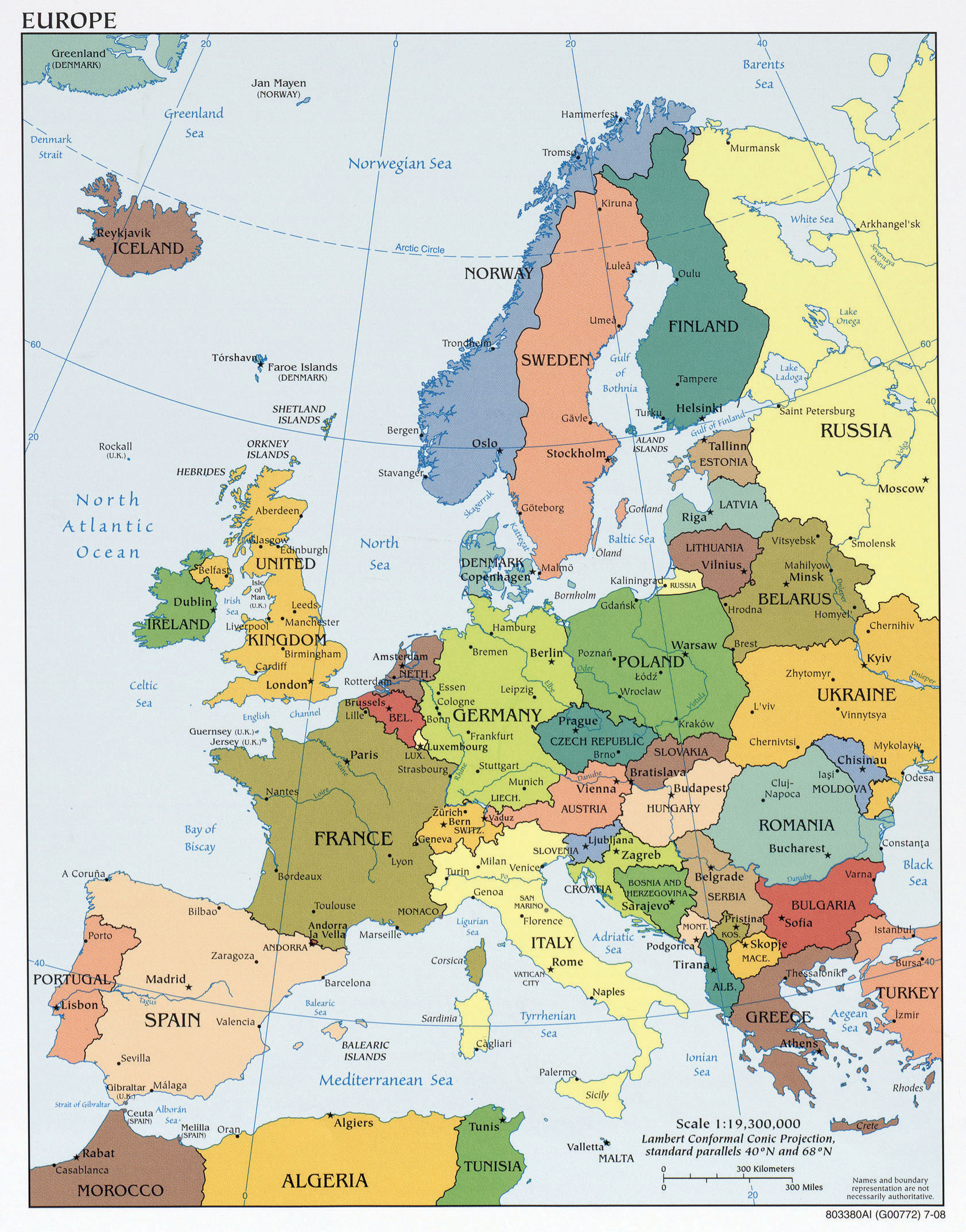
“Europe political map in 2008” by the CIA is in the Public Domain CC0 1.0.
Location and Climate
Europe is a northern continent. All the British Isles, for example, are at the latitude of Canada, and no part of the continent is as far south as the USA’s southern border states. Europe’s latitudinal position causes long summer days and long winter nights, particularly in its northern half.
The oceans exert significant influence on the world’s climates, an influence pronounced in Europe where no areas are far from the ocean, and prevailing winds carry the Atlantic’s influence far inland. Oceans absorb and store vast amounts of solar energy, particularly around the equator, and transport that heat with their currents. Ocean currents can move such warmed water for thousands of miles to colder latitudes, where it warms coastal areas. Water also resists temperature change, and thus maritime climates are often milder than continental ones, with smaller temperature variations from day to night as well as from winter to summer. Oceans Influence not only temperature but also precipitation patterns over wide regions of Europe and the rest of the world. However, interior Europe does not benefit from coastal waters and can have winters as cold as those found within the upper midwestern United States.
Figure 2.2 The Dominant Climate Types of Europe
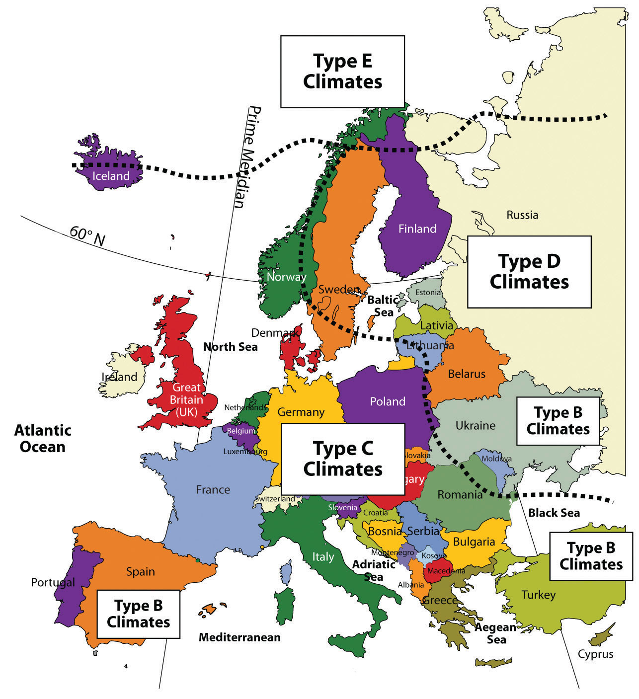
The Gulf Stream from the balmy Gulf of Mexico traverses northeastward across the Atlantic to Europe as the North Atlantic Drift, and is the most important current for Europe’s climate, warming western European nations. Most of Western Europe has a moderate type C climate. The current’s influence is highlighted by the fact that drizzly, mild coastal Scotland is at the same latitude as Hudson Bay in the interior of Canada, home to polar bears.
People living farther inland in Eastern Europe encounter the colder type D climates characteristic of the rest of northern Eurasia. The Mediterranean Sea moderates the temperature to the south, providing a type C climate around its shores. Type E Icecap climates occur near the Arctic Circle in Norway and in Iceland.
Four Main European Landform Regions
Europe is occupied by four main landform regions: the Alpine region, Central Uplands, Northern Lowlands, and Western Highlands. The topography of each has influenced the human societies that occupy them. Rivers are abundant in Europe and have provided adequate transportation for travel and trade throughout its history. Most of Europe is accessible by water transport either via the many rivers or along the extensive coastlines of the peninsulas and islands. Two main rivers divide Europe: the Danube and the Rhine. Both have their origins in the region of southern Germany on or near the border with Switzerland. The Rhine River flows north and empties into the North Sea in Rotterdam in the Netherlands, one of the world’s busiest ports. The Danube flows east through various major European cities, such as Vienna, Budapest, and Belgrade, before emptying into the Black Sea.
Figure 2.3 Four Main Landforms of Europe: Western Highlands, Northern Lowlands, Central Uplands, and the Alpine Region
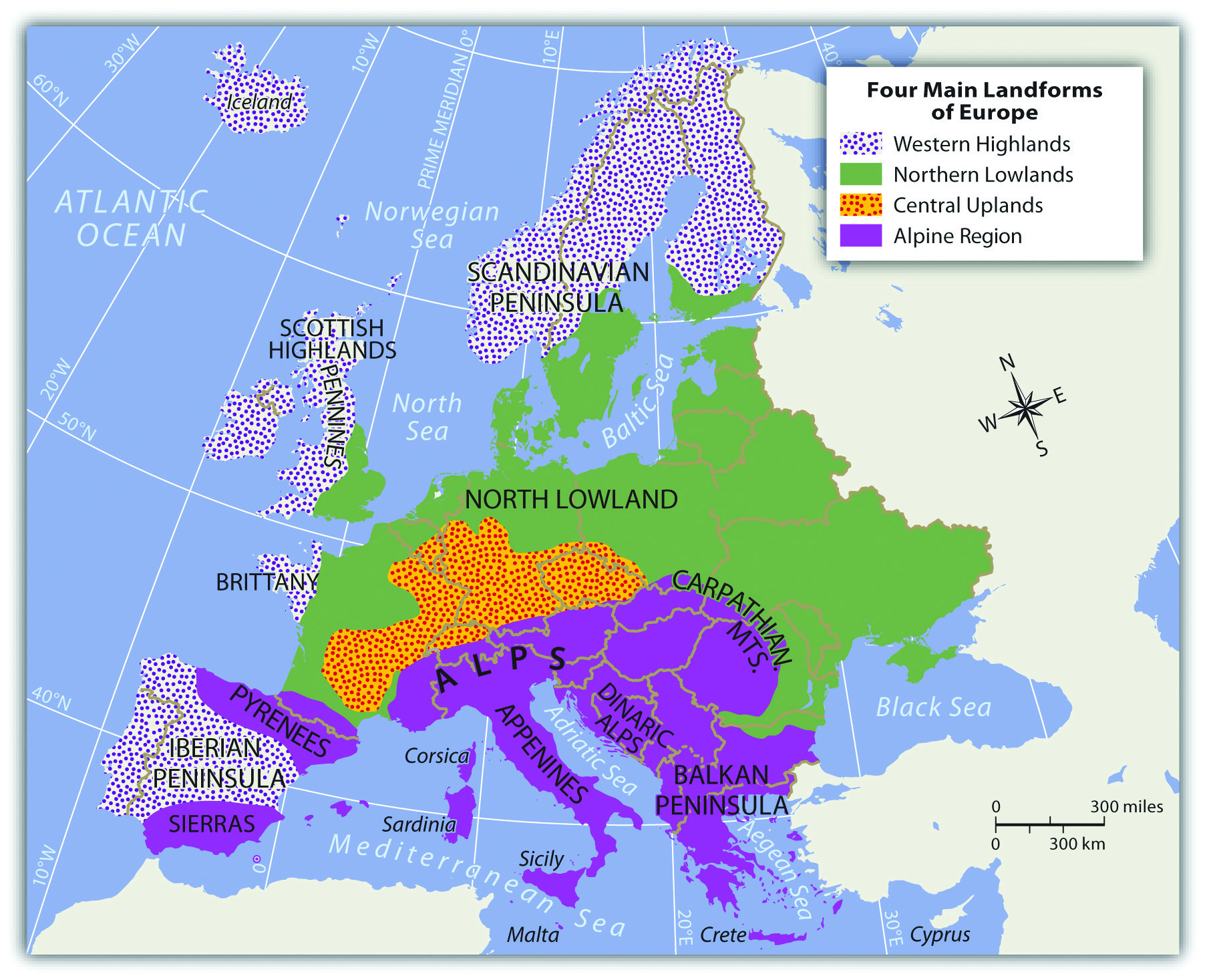
Alpine Region
The High Alps, which range from eastern France to Slovenia, are central to the Alpine region. Included in the Alpine Range are the Pyrenees, located on the border between France and Spain; the Apennines, running the length of Italy; the Carpathians, looping around Romania from Slovakia; and finally, the shorter Dinaric Alps in former Yugoslavia. Mountains usually provide minerals and ores that formed there when the earth’s internal processes created the mountains. Mountains also may isolate people by separating cultural groups.
Figure 2.4 The Alpine Region: Eiger, Mönch, and Jungfrau from Männlichen—Swiss Alps

“Eiger, Mönch und Jungfrau” by Steinmann is in the Public Domain CC0 1.0.
The Alpine region encircles the Mediterranean coastlines, which have more temperate type C climates that are particularly warm with hot, dry summers and cool, wet winters. This climate type allows for the cultivation of food products such as olives, citrus fruit, figs, apricots, and grapes. Evergreen scrub oaks and other drought-resistant shrubs are common in the Mediterranean region.
The Central Uplands
The region lying north of the main Alps, which includes a large portion of southern Germany extending eastward, is known as the Central Uplands. These foothills to the Alps are excellent sources of raw materials such as forest products and coal, which are valuable resources for industrial activities. The Central Uplands are also a good location for dairy farming and cattle raising. This middle portion of the continent has a mixed deciduous-coniferous forest, including oak, elm, and maple intermingled with pine and fir trees. There are four distinct seasons in this region with moderate amounts of precipitation year round.
Northern Lowlands
Figure 2.5

The Western Highlands meet the lowlands in central Scotland.
Photo by Royal Berglee is licensed under Creative Commons CC BY-NC-SA 4.0.
Similar to the breadbasket of the midwestern United States, Europe’s Northern Lowlands possess excellent farmland. Major agricultural operations here provide for the large European population. The land is flat to rolling with relatively good soils. The Northern Lowlands are a great plain that extends across northern Europe from southern France, north through Germany, and then east all the way to the Ural Mountains of Russia. This area is mostly used as farmland. The area also contains bogs, heaths, and lakes. The eastern part of this great plain, around Ukraine, is characterized by short grasslands known as steppes. It is a flat and relatively dry region with short grasses and widely used for agriculture. Being inland, it has great swings in temperature, both from day to night and from summer to winter. Winter temperatures in the eastern steppe can drop to below −40 °F, with summer temperatures reaching as high as 105 °F. This is similar to the steppes of Montana or North Dakota in the United States.
Western Highlands
On the western edges of the European continent arise short, rugged mountains that extend throughout Norway, parts of Britain, and portions of the Iberian Peninsula (Portugal and Spain). These Western Highlands hold sparser populations and are less attractive to large farming operations. Agriculture is usually limited to grazing livestock or farming in the valleys and meadows. The Scottish Highlands are noted for their wool products and Highland cattle. In England, the central chain of highlands called the Pennines proved valuable during the Industrial Revolution because they enabled hydropower and, later, coal mining. Coal mining was prominent in the highland regions of Wales. In the far northern regions of Scandinavia, tundra environments prevail. In this coldest and driest biome, permafrost dominates the landscape, and the land becomes soggy for brief periods during a few weeks of summer. The flora consists primarily of lichens, mosses, low shrubs, and wildflowers.
Natural Resources in Europe
The physical landforms of Europe provide a diversity and abundance of natural resources. European countries have gained wealth from the land and leveraged their geographic location to develop a powerhouse of economic activity for the global marketplace. Europe has placed a strong focus on manufacturing activity to take advantage of its natural resources. The highly urbanized society has struggled to find a balance between modernization and environmental concerns. Industrial activities have contributed to the degradation of the environment and the demise of a number of species.
Different regions of Europe are blessed with fresh water supplies, good soils, and various minerals. Chief among the mineral deposits in Europe is iron ore, which can be found in Sweden, France, and Ukraine. Other minerals exist in smaller quantities, including copper, lead, bauxite, manganese, nickel, gold, silver, potash, clay, gypsum, dolomite, and salt. Extraction activities have supported the continent’s industrialization.
Ready access to the Atlantic Ocean and a number of major seas, lakes, and rivers has elevated fish to an important natural resource in Europe. The seas around Europe provide about 10 percent of the world’s fish catches. Mirroring the situation around the world, European fishing activity increased as population increased. Europeans are becoming increasingly aware of the effects of overfishing. Stocks of Atlantic cod and Atlantic mackerel are at risk because of overfishing and changes in the environment that are affecting natural mortality and slowing spawning. Stocks of eastern North Atlantic bluefin tuna are also attracting attention for the same reason. Other species of fish in the North Atlantic and the Baltic Sea are overexploited. Changes to the fishery are a major concern both for ecological reasons and also because fish comprise such a significant portion of the European economy.
The countries of Europe, with the formation of the EU, began to work toward shared research and policies with respect to the fishery. The Common Fisheries Policy was drafted and includes strict and extensive rules and guidelines for fishing, particularly of cod. The rules are so strict and thus so controversial that Norway and Iceland decided to opt out of the EU instead of complying with them. The effect of these rules is incompletely known, but the cod stocks in the North Sea do not seem to be rebounding as quickly or substantially as expected.
Forest covers more than 40 percent of the continent’s land area. Forests exist primarily in the less populous Nordic and Baltic countries and in Central Europe. About half the forest land in Europe is privately owned, including large family holdings, holdings by forest industries, and small to very small holdings by thousands of individuals. Most forested land is managed, and about 85 percent of the forests produce exploitable resources. The percentage of forested land in Europe is rebounding because of an extensive tree-planting initiative since 2000.
Soil resources are of critical importance. Soil is necessary for growing food, supporting livestock, supporting other natural resources such as the forests, and supplying groundwater. Soil resources are only just beginning to receive attention in Europe. Problems to be addressed include loss of topsoil from development and building activities, older-style agricultural practices, mining, contamination from industries and other sources, and acidification as a result of acid rain.
Coal, now substantially depleted, is abundant in several areas of Great Britain, including some offshore areas, as well as in the industrial centers of Germany and Ukraine. Other coal deposits are in Belgium, France, Spain, the Czech Republic, Poland, Slovakia, and Russia. Coal is a major source of air pollution, such as acid rain, that has caused great harm to the forests of parts of Europe, including the Black Forest of southern Germany, which has also experienced heavy logging activity. Acid rain has also been a major concern in the northern countries, where wind currents carry pollutants north into Scandinavia from the industrial regions of Central Europe. In Scandinavia, acid rain has also diminished fish populations in many of the lakes. Petroleum and natural gas deposits exist underneath the North Sea and were first tapped in the 1970s. Five European countries have rights to these resources, including Norway, the United Kingdom, Denmark, the Netherlands, and Germany, with Norway holding the bulk of the rights. Although tapped only decades ago, half these reserves have been consumed.
Before the extraction of petroleum products from the North Sea, Russia and the former Soviet Union’s other republics supplied petroleum to Europe. These areas still have a number of active extraction operations. Hydroelectric power has been important in Europe as well. With both coal and oil resources largely depleted and the desire to avoid the environmental damage caused by dams, the European Energy Commission is devoting substantial energy and resources to encouraging the use of renewable resources such as wind and solar energy.
Key Takeaways
- The Gulf Stream provides a moderate type C climate for much of Western Europe. Eastern Europe can experience colder type D climates.
- Europe has four main physical landforms that provide a diversity of natural resources. The North European Lowland holds the majority of its agricultural potential.
- An increase in population has also increased the demand on the environment. Various environmental concerns are becoming more evident. Acid rain from industrialization has caused extensive damage to forests and fish populations in northern Europe. Atlantic fisheries are also experiencing a decline in production.
Discussion and Study Questions
- Identify and locate the four main physical landforms of Europe. What are the main features of each?
- How do these landforms and natural resources provide wealth, opportunities, and advantages to the European community?
- Why is there a higher concentration of acid rain in northern Europe? How is acid rain affecting the environment?
- What two rivers act to naturally divide Europe? Which rivers flow through Paris and London?
- Track the flow of each of the two main rivers and identify the major cities that each flows through.
- Where are the major mountain ranges of the Alpine region?
- How does the Alpine region contribute to the economies of the countries of Europe?
- Why do the countries of Western Europe have more moderate type C climates even though they are in the northern latitudes?
- How does agricultural production vary with physical landforms or climate changes?
- How are Europeans addressing the decline in the North Atlantic fishing industry?
Geography Exercise
Identify the following key places on a map:
- Alpine region
- Alps
- Apennines
- Black Forest
- Black Sea
- Carpathians
- Central Uplands
- Danube River
- Dinaric Alps
- Iberian Peninsula
- Mediterranean Sea
- North Sea
- Northern Lowlands
- Pyrenees
- Rhine River
- Scottish Highlands
- Strait of Gibraltar
- Ural Mountains
- Western Highlands
