Learning Objectives
- Outline the main physical features of the countries described in this section.
- Understand how cultural differences in religion and ethnicity continue to cause conflict and division in South Asian countries and regions.
- Outline how and why Kashmir is divided and its importance for the region.
- Describe how tourism has been a means of gaining wealth for the listed countries.
- Summarize the main environmental concerns that are apparent in each of the countries.
As detailed earlier, the Indian subcontinent is a large landmass that juts into the Indian Ocean along the southern side of Asia, between Afghanistan and Myanmar (Burma) and south of China. The Indian perimeter includes the southern countries of the Maldives and Sri Lanka, and the northern regions of the Punjab, Kashmir, Nepal, and Bhutan. This landmass has a long tectonic history and has been formed by the collision of the Indian Tectonic Plate with the Eurasian Plate. This tectonic collision has given rise to the highest mountain chains and ranges in the world along the northern and northwestern part of the Indian subcontinent—that is, the Himalayas.
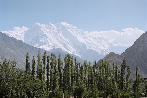
The Karakoram Mountains are located in northern Pakistan and Kashmir. Together with the other Himalayan Mountain ranges, they form an arc that stretches across the entire northern border of South Asia. Nepal and Bhutan are both located in the Himalayas. The Himalayan ranges have some of the highest peaks in the region, including Mount Everest (located on the border between Nepal and China) and K2 (located in Pakistan). In western Pakistan and western Afghanistan, the Hindu Kush mountain ranges that borders this area are found. The Indus River flows from the northern part of the Karakoram mountains and creates a large, fertile floodplain. Along its northern area, the Indus River System has four main tributaries. Together, these rivers constitute the five rivers of the Punjab regions of Pakistan and India; Punjab means the “land of the five rivers” in the Punjabi language.
Figure 9.9
The Punjab
Located on the western edge of Ganges Plain and central Indus River Valley, the region of Punjab historically has been a fertile agricultural region with a high population density. The 1947 partition of the Indian Subcontinent, split this large and homogeneous cultural area into Muslim majority west Punjab or Pakistani Punjab, and Sikh majority east Punjab or the Indian Punjab. Its river valleys are excellent areas for agricultural production and contribute heavily to the provisions needed to feed the enormous populations of the two countries. The people of both east and west Punjab, speak the Punjabi language, which is an Indo-European language, and are considered one of the main ethnic groups in South Asia. In Pakistan, Punjabis account for about 45 percent of the population.
Traditionally, Punjabis are farmers and warriors, and in modern times are associated with agricultural professions and military life. Punjabis in Pakistan are predominantly Muslim, although a Christian minority exists. Most of the Muslim populations of the Punjab migrated to Pakistan in 1947 and, thus, most of the Indian Punjabis are Sikh with a Christian minority.
The Punjab region of Pakistan and India is the homeland of the Sikhs and is the birthplace of Guru Nanak Dev (1469 CE – 1538 CE), the founder of Sikh religion. Sikh religion is a monotheistic faith that rejects the distinctions of caste, creed, race, social status, or gender. In Sikhism there is no priestly class. Every person is equally and fully responsible for leading a moral life, which eventually leads to universal salvation. Heaven and hell are not physical places, and God is the cosmic universal spirit. Historically, traditional Sikh men wear turbans and never cut their hair or beard. One prominent Sikh landmark and spiritual center is Golden Temple, located in the city of Amritsar in the Indian state of the Punjab. The other prominent place for Sikh people is the Nankana Sahib in central Pakistan, which is the birthplace of Guru Nanak. To facilitate the free movement of Sikh pilgrimage from the Indian Punjab, the government of Pakistan has constructed an exclusive corridor, which allows Sikh pilgrims from India to visit Nankana Sahib bypassing the normal immigration channels.
During British colonial occupation of South Asia, Sikhs were elevated to positions of power to help the British rule over Muslim and Hindu populations. After the partition, the Sikhs in India, are often overshadowed by the large Hindu and Muslim populations. There is a continuing desire, but active movements existed in the 1970s and 1980s, to create a Sikh nation-state in Punjab free from Muslim or Hindu domination, called Khalistan. The Indian government has, however, cracked down on militant movements that support the Khalistan concept. Khalistan does not have the support of the Pakistani and Indian governments and is not likely to become a reality any time soon. However, it is an example of a devolutionary push within for a nation-state for independence of a particular group of people with similar aspirations or heritage.
The Kingdom of Kashmir
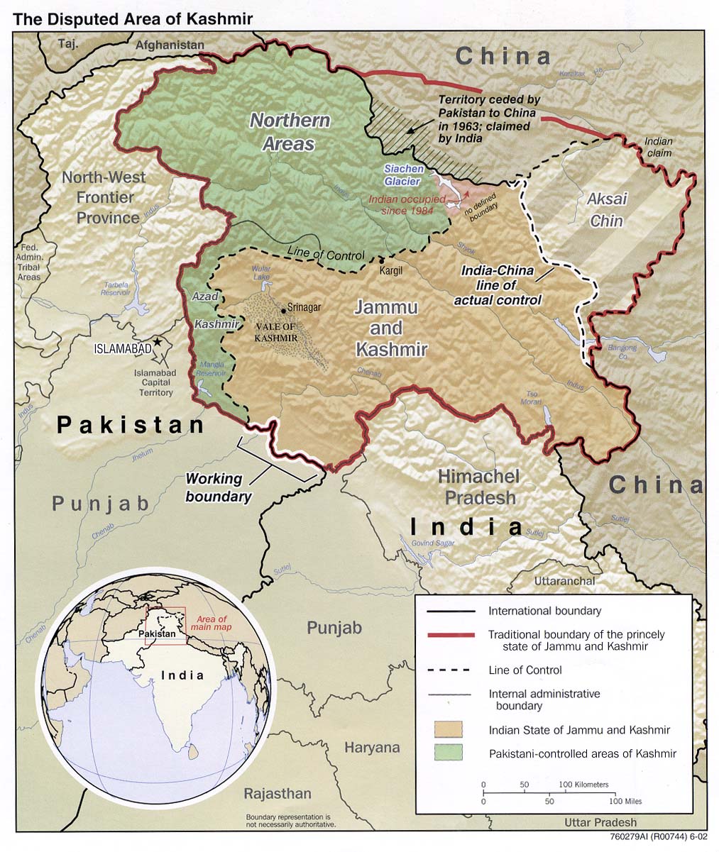
Located in the high mountains Himalayas and Karakoram, is the former Kingdom of Kashmir, an autonomous princely state at the time of partition. The partition plan left the fate of numerous independent princely states up to their rulers. After the partition, these states had an option of becoming a part of either country. Some of them were quickly absorbed. For instance, a large state of Hyderabad Deccan was absorbed into the Indian federation shortly after the independence of India. Others were also gradually absorbed into the federation of each country. No independent princely states currently exist in either India, Pakistan, or Bangladesh. In 1947, the maharajah of Kashmir chose not to be a part of either country but to remain independent. Unlike the state of Hyderabad Deccan, which had a Hindu majority population but Muslim ruler (or “Nizam”), Kashmir was and still is Muslim majority, but the ruler is Hindu. The maharaja’s refusal to join with the newly created Pakistan resulted in uprising, both within his domain and across the border in Pakistan. The maharajah asked the Indian military for assistance. India was more than pleased to oblige and saw it as an opportunity to oppose Pakistan one more time. This conflict resulted in the first India-Pakistan war in 1948. Today Kashmir is divided, with Pakistan controlling the northern region, India controlling the southern region. The dividing line is known as the cease-fire line or Line of Control (LoC). Marking the position of the armies of both countries at the time of conflict in 1948 (Figure 9.10). The LoC is a United Nation monitored line that continues to serve as a de facto international border between the two countries in that area. Although the LoC is not an internationally recognized international border between India and Pakistan, both countries tend to show it as an international border on their political maps. Both countries fought a major war in 1965 and have also come dangerously very close to potentially nuclear conflict over the area on several occasions. However, the legal status of Kashmir remains unresolved and disputed.
Figure 9.10 The Issues with Kashmir

Pakistan controls the northern areas, India controls Jammu and Kashmir, and China controls the eastern portion, labeled Aksai Chin on this map. All three countries have nuclear weapons, and it seems apparent that none of the countries wants to start a nuclear war.
Updated from map courtesy of University of Texas Libraries.
The Kingdom of Bhutan
The small Himalayan Kingdom of Bhutan is located between China and India. The country is about half the size of the US state of Kentucky and has fewer than one million people. The Himalayan Mountain peaks here reach more than twenty-three thousand feet.The local people call their country the “Land of the Thunder Dragon” because of the harsh storms they experience. Bhutan has large areas of natural habitat that have not been disturbed by human activity. The natural environment and the unique heritage and culture of people make Bhutan an attractive destination for world travelers.
Bhutan is a small country without much industry or corporate economic activity. Forestry and agriculture are the main economic activities, which employ approximately 60 percent of the country’s population. Grazing livestock and subsistence agriculture are the primary types of farming. Increasing the country’s modest infrastructure is hampered by its high mountains and remote location. India is Bhutan’s main trading partner and has played an important role in the country’s development and economic situation.
.Figure 9.11 Bhutan’s Famous Taktshang Buddhist Monastery, Commonly Known as the Tiger’s Nest

The unique landscapes and cultural experience that Bhutan offers to travelers have promoted tourism as an increasing economic activity.
Avinash singh – taktsand – CC BY 2.0.
Modern transportation and communication technologies are being introduced in Bhutan and are changing how the country is connected to the rest of the global economy. Satellite and cable television, mobile phone networks, the Internet, and major airline service are opening the doors of opportunity and interaction between the people of Bhutan and the rest of the world. Introduction of technological services has prompted Bhutan’s government to take steps to protect its environment and unique heritage. Tourism has become a major focus of the changes. The country has stepped up its efforts to develop tourism, but it remains highly selective in its requirements and regulations. These measures are put in place to ensure that the environmental health of the country remains intact and that there is minimal cultural impact from outsiders.
One of the principles of the government in regulating development projects has been the concept of gross national happiness (GNH), which is used as a guide to determine the impact of a project on the culture and people of Bhutan. The stern measures regarding development have protected the country from serious environmental degradation and have helped to sustain the lifestyles of the Bhutanese people. Some measures may appear harsh to outsiders, but the country is implementing these measures to promote the health and well-being of its people. For example, tobacco products are banned from being sold in the country. Democratic elections are becoming standard after centuries of rule by a monarchy. The intent of the transition is to provide the people with more direct control of their government and country.
Interesting points about the culture of Bhutan include the issue of marriage. Marriages based on love are becoming more common in the cities, while arranged marriages remain a tradition in many of the smaller villages. Under the current legal system, women have the right to inheritance. Homes and personal possessions are passed down through a family’s female children. Traditionally, male children do not inherit. Men are expected to earn their own livelihood and if they get married will most often live in the wife’s house.
Buddhism is the state religion of Bhutan and is followed by about 75 percent of the population. Hinduism is the second largest religion and is followed by the remaining 25 percent of the population.
Archery is the national sport of Bhutan. Most villages regularly hold archery competitions, which usually include festivities of serving food and conducting community events.
The Kingdom of Nepal
The landlocked country of Nepal is the second Himalayan kingdom. The country is buffered from the outside world by India and China (Figure 9.12). Nepal is about the same size in physical area as Bangladesh and is home to Mt. Everest and about thirty million people. More than 80 percent of the population works in the farming sector. The country has been facing serious environmental problems including deforestation and soil erosion. Trees are cut down to build houses and for fuelwood. Without trees to hold the soil, the monsoon rains wash soil from steep mountain slopes into the valleys. Nepal’s best farmland is in the Tarai lowlands of southern Nepal, while the north is quite mountainous. The towering elevation of the Himalayas restricts human habitation in the north. High population growth has also been outstripping the country’s economic growth rate in recent years.
Figure 9.12 The Himalayan Mountains and the Tarai Lowlands of Nepal

CIA World Factbook – public domain.
Nepal has an abundance of tourist attractions, Mt. Everest, its best known. In addition, there are hundreds of ancient temples and monasteries. Swift flowing streams and high-mountain terrain support a modest trekking industry,there are hundreds of ancient temples and monasteries, which also attract a large number of international tourists.. Visitors to Nepal have an opportunity to glimpse a rich culture that few outsiders can witness. The downside is that tourism demands an investment in infrastructure and services. Such investments direct funds away from schools, medical clinics, and public services needed by the Nepalese people. Income from tourism is needed and always welcome, but the trade-off with investments is a difficult choice to make. Tourism in Nepal is not as restrictive as that of Bhutan, and the unique physical and cultural landscapes will continue to draw travelers from throughout the world.
Figure 9.13 The Deforested Landscape of Nepal

Deforestation is a serious problem. The trees are cut down for firewood and building materials. The winding road connects Kathmandu with Tibet.
Wikimedia Commons – public domain.
Hinduism is the main religion in Nepal, but a blend with Buddhism is more prevalent in the north. The guardian deity of Nepal is Shiva. Pashupatinath Temple, the world’s most significant Shiva worship site, is located in the capital city of Kathmandu. This Shiva temple is not only a UNESCO World Heritage Site but a major destination for Hindu pilgrims from around the world. Buddhist and Hindu beliefs often mix in Nepal. There are certain situations where the same deities and temples can be honored or worshiped by members of both religions.
Near the city of Bhairahawa (Siddharthanagar), on the border with India, is another UNESCO World Heritage Site, this one focusing on the birthplace of the Siddhartha Gautama, the founder of Buddhism, who was born about C. 563 BCE, near the city of Lumbini. Several monasteries and temples were built there in his honor. An entire development zone is restricted to monasteries and temples only. Lumbini is a major pilgrimage site for Buddhist believers from around the world.
Nepal has been free of British influence since 1947 but has had difficulty in establishing a stable central government. The royal family in charge of the kingdom was replaced in 1951, and further democratic reforms were made in 1990. The Maoist Communist partisans from China have been active in insurgent activities. Frequent protests and civil unrest in recent years have caused political instability, which has discouraged tourism and has depressed the economy even further. To end the conflict, in 2006, a comprehensive peace agreement between the government and the Communist Party of Nepal (Maoist) was signed. The agreement called for political, economic, and social change in the country, and for the election of a constituent assembly. The agreement also called for the nationalization of all royal property, and the right of the constitutional assembly to decide by a simple majority whether to retain the monarchy as an institution. Ensuing elections created the establishment of a federal democratic republic. The first president of Nepal was sworn into office in 2008. There is still much tension in the country between those loyal to the royal family and those wanting the royal family to be dissolved. Without a stable government, economic and political progress in Nepal will be a serious challenge.
Sri Lanka
Sri Lanka is a beautiful island about half the size of Nepal. The island has a warm, tropical type A climate, with forested hills and mountains in the center of the country. Rivers in Sri Lanka flow from the center outward to water the farm fields of rice and other crops. The best farmland is in the southwestern portions of the island (Figure 9.14). Cinnamon is native to the island and has been cultivated since colonial times as an important export cash crop. Coconuts, coffee, and tea are also important export products. The island is home to various national parks, four biosphere reserves, and several wild elephant herds. Sri Lanka has the potential to become a major tourist destination with high incomes and a hub for international trade. Factors working against Sri Lanka reaching its potential are not based on its physical geography or location, but rather they are linked back to colonialism and cultural or ethnic divisions between the Buddhist Sinhalese majority concentrated mostly in the southern half of the country, and the Hindu Tamil minority in the north and northeast. Sinhalese account for about 75 percent of the population, and Tamil account for about 18 percent of the population. The remaining 7 percent of the population includes mostly Muslims and Christians minorities.

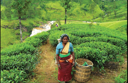
Sinhalese moved to the island of Sri Lanka about 2,500 years ago from somewhere in northern India. They brought with them Buddhism and the Sinhala language, which belongs to the Indo-European language family. They established themselves on the island for centuries. Sri Lanka was first colonized by Portugal, then by Holland, and finally the British, who lumped it with their British Indian Empire. When the British took control of Sri Lanka, it was called Ceylon. The British changed its name to Sri Lanka in 1972. The higher elevations of the center of the island were excellent for tea production; the British colonial government established tea plantations there. Ceylon Tea is still regarded as the best quality tea among the tea drinkers of South Asia. To work on tea plantations, Britain brought thousands of additional Tamil laborers from southern India across the Palk Strait to Ceylon. Most of the Tamil speak a Dravidian language and follow the Hindu religion.
Figure 9.15 Picking Tea in Sri Lanka
Differences in religion, ethnicity, and politics have brought the country to a halt on various occasions. From 1983 to 2009, Sri Lanka experienced a devastating conflict between the Sri Lankan government and the Tamil Tigers, a rebel group who represented the Tamil people in the north and fought for a separate autonomous region for Tamils called Tamil Eelam in the north. The civil war ended in 2009, but almost two decades of conflict cost Sri Lanka considerable human and economic loss, and devastated Sri Lanka’s tourism industry.
The Maldives
Just north of the Equator in the Indian Ocean to the southwest of India lie the Maldives, a group of low-lying islands that consists of twenty-six atolls encompassing a territory of only about 115 square miles. Within the atolls are approximately 1,200 small islands, of which about 200 are inhabited. Portugal controlled the Maldives from 1558 during their colonial expansion into Asia. Holland took over from the Portuguese in 1654. The Maldives became a British protectorate in 1887, which lasted until 1965, when independence was achieved. Three years later the country became a republic. The Maldives is a country with many extremes. It is Asia’s smallest nation in both physical area and population. The island nation has the smallest physical area of any country with a majority Muslim population. The average elevation—four feet, eleven inches above sea level—is the lowest in the world for any country.
Fishing and tourism are the chief methods for Maldivians to earn a living. Tourism has increased in recent years. The many islands and atolls are attractive destinations for world travelers. The first tourist resort opened in 1972. Since that time, dozens of world-class resort facilities have opened for business across the archipelago. Tourism is the country’s number one means of gaining wealth. The coral reefs that make up the island chain are excellent for diving and water sports. The tropical climate and miles of sandy beaches provide for an attractive tourism agenda.
The Maldives is an example of an entire country that could be in danger of flooding because of climate change if polar ice melts and sea levels rise. Concerns over the future of the islands gave reason for the president of the country to announce a plan in 2008 to purchase land in other countries in case sea levels rise to a point where the Maldives are no longer habitable. The purchase of land from tourism receipts would provide a place for the Maldivians to move in case they had to evacuate the islands. The administration of the Maldives has worked hard to lobby the international community to address the increase in greenhouse gas emissions and the possibility of an increase in sea level caused by the global warming aspect of climate change.
Key Takeaways
- The Punjab is a highly productive agricultural region located partly in Pakistan and partly in India. The region is home to the Sikh population, which has proposed having its own nation-state.
- Kashmir is divided between Pakistan, China, and India. The religious differences and the control of a valuable water source are at the core of this conflict.
- Nepal borders the Himalayan Mountains and has an economy based on agriculture and tourism. High population growth has been stripping the land of trees, causing serious deforestation issues and soil erosion.
- The Kingdom of Bhutan has placed major restrictions on tourism to protect its environment and limit outside influences on its culture.
- The beautiful tropical island of Sri Lanka experienced a low-level civil war for decades between the Sinhalese Buddhist majority and the Tamil Hindu minority. The island has an excellent location and potential for economic development.
- The archipelago of the Maldives is a small country that depends on tourism for its economic survival. The low elevation of its land area makes it subject to flooding due to the effects of climate change.
Discussion and Study Questions
- Why is the Punjab region vital to both Pakistan and India?
- What has been one political goal of the Sikhs living in the Punjab?
- What three countries control parts of the Kingdom of Kashmir?
- Why is the region of Kashmir vital to South Asia’s viability?
- Why is Bhutan so selective about admitting tourists?
- Explain Bhutan’s guiding philosophy regarding development.
- Why is Nepal experiencing environmental degradation?
- What was the civil war about in Sri Lanka? What did each side want?
- What is it about each country listed that is attractive to the tourism industry?
- What plan was announced to address the Maldives’s environmental concerns?
Geography Exercise
Identify the following key places on a map:
- Jaffna Peninsula
- Lumbini
- Mt. Everest
- Polk Strait
- Tarai lowlands
